- 4 replies
- 2,366 views
- Add Reply
- 0 replies
- 1,871 views
- Add Reply
- 0 replies
- 1,091 views
- Add Reply
- 1 reply
- 1,639 views
- Add Reply
- 2 replies
- 1,511 views
- Add Reply
HTML POP up in shape file with relative path

By souvik.gis,
Hello,
I am facing a problem in HTML image attaching with shape file. I need to attach image with relative path not absolute. I have tried all <img src="picture.jpg"> or <img src="images/picture.jpg"> etc. In the case of absolute path images are displaying properly but how can I make the path relative. Please help.
SAR Tomography
By Yasmine,
Hi,
Please is there anyone already working on tomographic reconstruction of urban areas using spaceborne data ???
Has somebody tried to detect/model sea water pollution with hyper-spectral remote sensing?

By Stefan,
Has somebody tried to detect/model sea water pollution with hyper-spectral remote sensing?
- near-shore (about 50km)
- pollution caused by metal smelter (zinc, lead)
- intended RS approach: UAV
MapSCII - Map on your terminal

By Lurker,
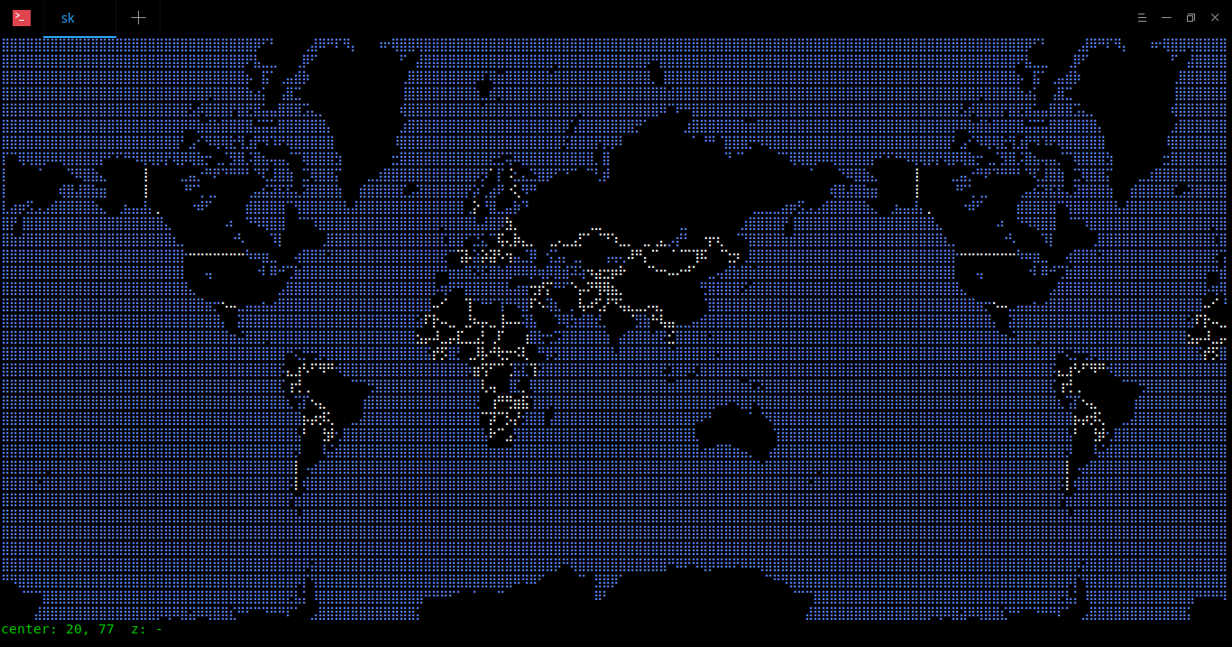
First time I will post it to software section, but hell , this only for fun so I change to general topic, enjoy the fun
Say hello to MapSCII, a Braille and ASCII world map renderer for your xterm-compatible terminals. It supports GNU/Linux, Mac OS, and Windows. We can use our mouse pointer to drag and zoom in and out a location anywhere in the world map. The other notable features are;
Discover Point-of-Interests around any given location
Highly customizable layer styling with Map
change detection

By nafiqah,
Hello, I have a question regarding landuse-landcover change detection. Is it possible to detect changes of LULC due to hazard event (earthquake and cascading hazards) occurred at particular area? the changes I want to detect are vegetation and built-up area. The hazard is occurred on 5 June 2015. The satellite image acquired is on August 2014 (10 months before hazard events) and December 2015 (6 months after hazard events). I used object-based change detection using post-classification comparis
-
Forum Statistics
8.8k
Total Topics43.5k
Total Posts
-
Latest Posts
-
-

-
 Are you ready to level up your geospatial skills? Join our comprehensive training course covering ArcMap, ArcGIS Pro, and ArcOnline—the essential tools for modern spatial analysis and programming! What You’ll Learn: Core functionalities of ArcMap & ArcGIS Pro Cloud-based mapping with ArcGIS Online Automating workflows with Python & ModelBuilder Creating interactive web maps & apps Who Should Enroll? GIS beginners & professionals Urban planners, environmental scientists, & data analysts Developers looking to integrate spatial programming Why Choose This Course? Hands-on projects & real-world applications Expert-led sessions & flexible learning Limited slots available! Click here to register. Let’s shape the future of spatial data together!
 -
GPS is an incredible piece of modern technology. Not only does it allow for locating objects precisely anywhere on the planet, but it also enables the turn-by-turn directions we take for granted these days — all without needing anything more than a radio receiver and some software to decode the signals constantly being sent down from space. [Chris] took that last bit bit as somewhat of a challenge and set off to write a software-defined GPS receiver from the ground up. As GPS started as a military technology, the level of precision needed for things like turn-by-turn navigation wasn’t always available to civilians. The “coarse” positioning is only capable of accuracy within a few hundred meters, so this legacy capability is the first thing that [Chris] tackles here. It is pretty fast, though, with the system able to resolve a location in 24 seconds from cold start and then displaying its information in a browser window. Everything in this build is done in Python as well, meaning that it’s a great starting point for investigating how GPS works and for building other projects from there. The other thing that makes this project accessible is that the only other hardware needed besides a computer that runs Python is an RTL-SDR dongle. These inexpensive TV dongles ushered in a software-defined radio revolution about a decade ago when it was found that they could receive a wide array of radio signals beyond just TV. source: Hackaday and GitHub - chrisdoble/gps-receiver
-
-
Latest Topics
-
-
Recent Achievements


