- 0 replies
- 104 views
- Add Reply
- 3 replies
- 3,138 views
- Add Reply
- 0 replies
- 427 views
- Add Reply
- 0 replies
- 740 views
- Add Reply
- 0 replies
- 535 views
- Add Reply
Researchers build high-resolution lidar with lowest-power laser

By Lurker,
Researchers at the University of Science and Technology of China (USTC) have developed a compact and lightweight single-photon LiDAR system that can be deployed in the air to generate high-resolution three-dimensional images with a low-power laser.
The technology could be used for terrain mapping, environmental monitoring, and object identification, according to a press release.
LiDAR, which stands for Light Detection And Ranging, is extensively used to determine geospatial informatio
Lyzenga Algorithm for Shallow Water Mapping

By Agha,
Hello folks!
I am trying to use the Lyzenga Algorithm for estimating the depth of water in shallower areas, probably depths under 8-10 meters of lakes.
First of all, how accurate is this algorithm in practice?
Secondly, lets say i have the band values. can someone explain me how to retrieve those depths?
I am following the "Lyzenga Algorithm for Shallow Water Mapping Using Multispectral Sentinel-2 Imageries in Gili Noko Waters" paper, but there are 3 steps of getting NDWIs, NDCIs a
The Transformative Impact of GIS Mapping in Humanitarian Assistance

By IRES,
Understanding GIS Mapping
GIS Mapping is a technology and process used to capture, store, analyze, manage, and visualize geographic or spatial data. It combines geographical information such as locations and terrain features, with various types of data like environmental, social, economic, and demographic information, to create detailed and layered maps. These maps are powerful tools for understanding and interpreting spatial relationships, patterns, and trends.
Components of GI
TinyVQA, a compact multimodal visual question
By Lurker,
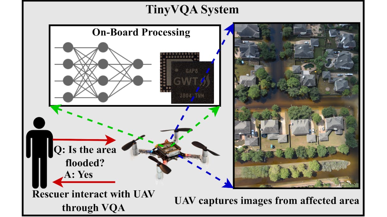
Multimodal machine learning models have been surging in popularity, marking a significant evolution in artificial intelligence (AI) research and development. These models, capable of processing and integrating data from multiple modalities such as text, images, and audio, are of great importance due to their ability to tackle complex real-world problems that traditional unimodal models struggle with. The fusion of diverse data types enables these models to extract richer insights, enhance decisi
AI Generates 3D City Maps From Single Radar Images
By Lurker,
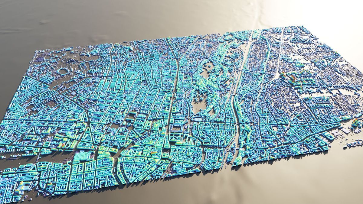
A new machine learning system can create height maps of urban environments from a single synthetic aperture radar (SAR) image, potentially accelerating disaster planning and response.
Aerospace engineers at the University of the Bundeswehr in Munich claim their SAR2Height framework is the first to provide complete—if not perfect—three-dimensional city maps from a single SAR satellite.
When an earthquake devastates a city, information can be in short supply. With basic services disrupte
-
Forum Statistics
8.7k
Total Topics43.2k
Total Posts
-
Latest Posts
-
my previous post address your first question actually 😁 I saw that you already got the the equation for the band value and the depth, so it should be okay you directly apply it to get depth value
-
Can you please address my question ?) is there any previous steps before calculation of models?
-
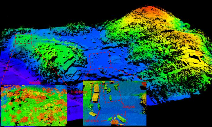
Researchers at the University of Science and Technology of China (USTC) have developed a compact and lightweight single-photon LiDAR system that can be deployed in the air to generate high-resolution three-dimensional images with a low-power laser. The technology could be used for terrain mapping, environmental monitoring, and object identification, according to a press release. LiDAR, which stands for Light Detection And Ranging, is extensively used to determine geospatial information. The system uses light emitted by pulse lasers and measures the time taken by the reflected light to be received to determine the range, creating digital twins of objects and examining the surface of the earth. A common application of the system has been to help autonomous driving systems or airborne drones determine their environments. However, this requires an extended setup of LIDAR sensors, which is power-intensive. To minimize such sensors’ energy consumption, USTC researchers devised a single-photon lidar system and tested it in an airborne configuration. The single-photon lidar The single-photon lidar system is made possible by detection systems that can measure the small amounts of light given out by the laser when it is reflected. The researchers had to shrink the entire LiDAR system to develop it. It works like a regular LiDAR system when sending light pulses toward its targets. To capture the small amounts of light reflected, the team used highly sensitive detectors called single-photon avalanche diode (SPAD) arrays, which can detect single photons. To reduce the overall system size, the team also used small telescopes with an optical aperture of 47 mm as receiving optics. The time-of-flight of the photons makes it possible to determine the distance to the ground, and advanced computer algorithms help generate detailed three-dimensional images of the terrain from the sensor. “A key part of the new system is the special scanning mirrors that perform continuous fine scanning, capturing sub-pixel information of the ground targets,” said Feihu Xu, a member of the research team at USTC. “Also, a new photon-efficient computational algorithm extracts this sub-pixel information from a small number of raw photon detections, enabling the reconstruction of super-resolution 3D images despite the challenges posed by weak signals and strong solar noise.” Testing in real-world scenario To validate the new system, the researchers conducted daytime tests onboard a small airplane in Yiwu City, Zhejiang Province. In pre-flight ground tests, the LiDAR demonstrated a resolution of nearly six inches (15 cm) from nearly a mile (1.5 km). The team then implemented sub-pixel scanning and 3D deconvolution and found the resolution improved to 2.3 inches (six cm) from the same distance. “We were able to incorporate recent technology developments into a system that, in comparison to other state-of-the-art airborne LiDAR systems, employs the lowest laser power and the smallest optical aperture while still maintaining good performance in detection range and imaging resolution,” added Xu. The team is now working to improve the system’s performance and integration so that a small satellite can be equipped with such tech in the future. “Ultimately, our work has the potential to enhance our understanding of the world around us and contribute to a more sustainable and informed future for all,” Xu said in the press release. “For example, our system could be deployed on drones or small satellites to monitor changes in forest landscapes, such as deforestation or other impacts on forest health. It could also be used after earthquakes to generate 3D terrain maps that could help assess the extent of damage and guide rescue teams, potentially saving lives.”
-
comparison of shallow water depth algorithm https://ejournal2.undip.ac.id/index.php/jkt/article/view/16050
-
-
Latest Topics
-
-
Recent Achievements


