- 3 replies
- 4,615 views
- Add Reply
- 0 replies
- 1,716 views
- Add Reply
- 0 replies
- 5,020 views
- Add Reply
- 0 replies
- 10,333 views
- Add Reply
- 0 replies
- 1,041 views
- Add Reply
Lyzenga Algorithm for Shallow Water Mapping

By Agha,
Hello folks!
I am trying to use the Lyzenga Algorithm for estimating the depth of water in shallower areas, probably depths under 8-10 meters of lakes.
First of all, how accurate is this algorithm in practice?
Secondly, lets say i have the band values. can someone explain me how to retrieve those depths?
I am following the "Lyzenga Algorithm for Shallow Water Mapping Using Multispectral Sentinel-2 Imageries in Gili Noko Waters" paper, but there are 3 steps of getting NDWIs, NDCIs a
The Transformative Impact of GIS Mapping in Humanitarian Assistance

By IRES,
Understanding GIS Mapping
GIS Mapping is a technology and process used to capture, store, analyze, manage, and visualize geographic or spatial data. It combines geographical information such as locations and terrain features, with various types of data like environmental, social, economic, and demographic information, to create detailed and layered maps. These maps are powerful tools for understanding and interpreting spatial relationships, patterns, and trends.
Components of GI
TinyVQA, a compact multimodal visual question

By Lurker,
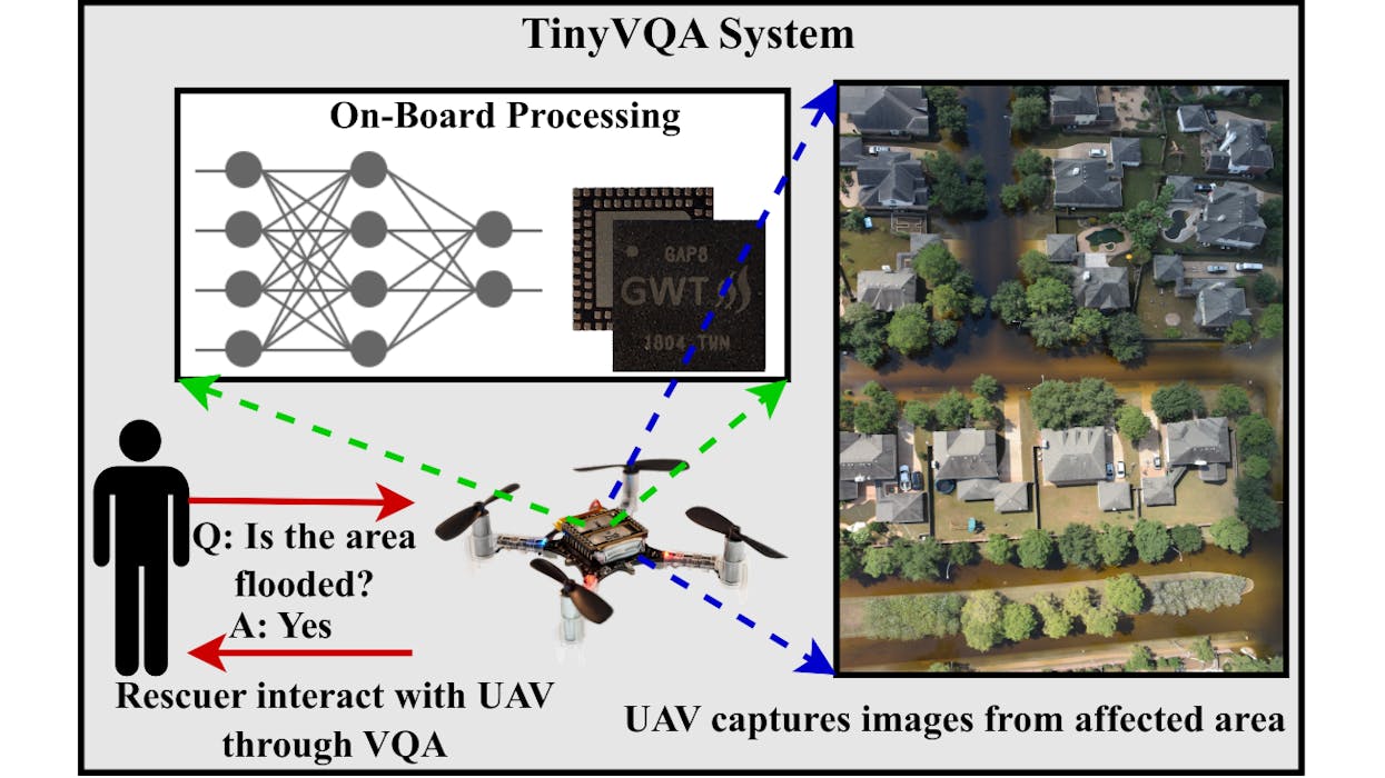
Multimodal machine learning models have been surging in popularity, marking a significant evolution in artificial intelligence (AI) research and development. These models, capable of processing and integrating data from multiple modalities such as text, images, and audio, are of great importance due to their ability to tackle complex real-world problems that traditional unimodal models struggle with. The fusion of diverse data types enables these models to extract richer insights, enhance decisi
AI Generates 3D City Maps From Single Radar Images
By Lurker,
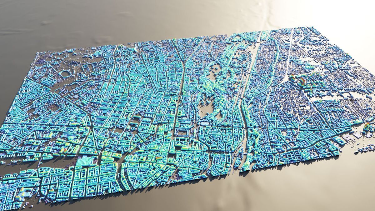
A new machine learning system can create height maps of urban environments from a single synthetic aperture radar (SAR) image, potentially accelerating disaster planning and response.
Aerospace engineers at the University of the Bundeswehr in Munich claim their SAR2Height framework is the first to provide complete—if not perfect—three-dimensional city maps from a single SAR satellite.
When an earthquake devastates a city, information can be in short supply. With basic services disrupte
AI reveals secret roads endangering the world's rainforests
By Lurker,
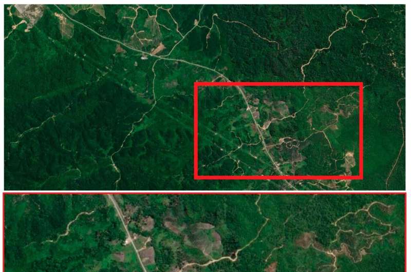
Satellite images analyzed by AI are emerging as a new tool in finding unmapped roads that bring environmental destruction to wilderness areas.
James Cook University's Distinguished Professor Bill Laurance was co-author of a study analyzing the reliability of an automated approach to large-scale road mapping, using convolutional neural networks trained on road data, using satellite images.
He said the Earth is experiencing an unprecedented wave of road building, with some 25 million kil
-
Forum Statistics
8.7k
Total Topics43.5k
Total Posts
-
Latest Posts
-
-

-
NASA and the Italian Space Agency made history on March 3 when the Lunar GNSS Receiver Experiment (LuGRE) became the first technology demonstration to acquire and track Earth-based navigation signals on the Moon’s surface. The LuGRE payload’s success in lunar orbit and on the surface indicates that signals from the GNSS (Global Navigation Satellite System) can be received and tracked at the Moon. These results mean NASA’s Artemis missions, or other exploration missions, could benefit from these signals to accurately and autonomously determine their position, velocity, and time. This represents a steppingstone to advanced navigation systems and services for the Moon and Mars. “On Earth we can use GNSS signals to navigate in everything from smartphones to airplanes,” said Kevin Coggins, deputy associate administrator for NASA’s SCaN (Space Communications and Navigation) Program. “Now, LuGRE shows us that we can successfully acquire and track GNSS signals at the Moon. This is a very exciting discovery for lunar navigation, and we hope to leverage this capability for future missions.” The road to the historic milestone began on March 2 when the Firefly Aerospace’s Blue Ghost lunar lander touched down on the Moon and delivered LuGRE, one of 10 NASA payloads intended to advance lunar science. Soon after landing, LuGRE payload operators at NASA’s Goddard Space Flight Center in Greenbelt, Maryland, began conducting their first science operation on the lunar surface. With the receiver data flowing in, anticipation mounted. Could a Moon-based mission acquire and track signals from two GNSS constellations, GPS and Galileo, and use those signals for navigation on the lunar surface? Then, at 2 a.m. EST on March 3, it was official: LuGRE acquired and tracked signals on the lunar surface for the first time ever and achieved a navigation fix — approximately 225,000 miles away from Earth. Now that Blue Ghost is on the Moon, the mission will operate for 14 days providing NASA and the Italian Space Agency the opportunity to collect data in a near-continuous mode, leading to additional GNSS milestones. In addition to this record-setting achievement, LuGRE is the first Italian Space Agency developed hardware on the Moon, a milestone for the organization. The LuGRE payload also broke GNSS records on its journey to the Moon. On Jan. 21, LuGRE surpassed the highest altitude GNSS signal acquisition ever recorded at 209,900 miles from Earth, a record formerly held by NASA’s Magnetospheric Multiscale Mission. Its altitude record continued to climb as LuGRE reached lunar orbit on Feb. 20 — 243,000 miles from Earth. This means that missions in cislunar space, the area of space between Earth and the Moon, could also rely on GNSS signals for navigation fixes. source: NASA
-
 Dear, could someone share again the link to download this soft please. best regards,
-
-
Latest Topics
-
-
Recent Achievements
-


")


