- 0 replies
- 1,131 views
- Add Reply
- 0 replies
- 905 views
- Add Reply
- 0 replies
- 1,092 views
- Add Reply
- 0 replies
- 1,072 views
- Add Reply
- 0 replies
- 981 views
- Add Reply
Airbus has opened the state-of-the-art satellite integration and space technology centre

By Lurker,
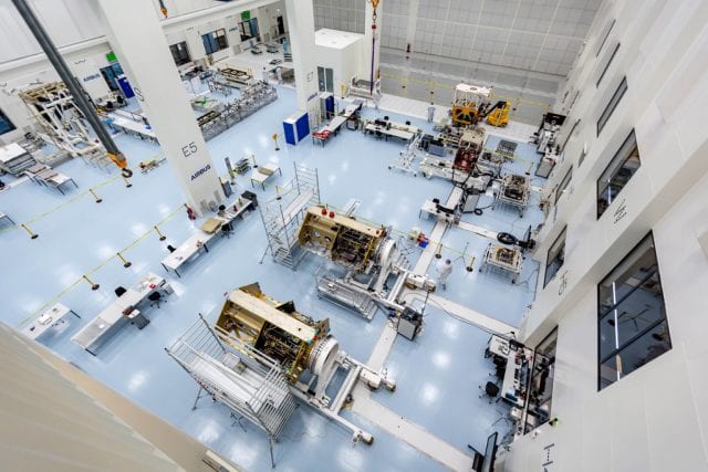
Airbus’ Friedrichshafen site has opened Europe’s most state-of-the-art satellite integration and space technology center, known as the Integrated Technology Centre (ITC). The ITC, which triples the area of cleanroom space to 4,200 m2, is dedicated to building satellites, probes, space instruments and experimental technologies. The center took only two years to build at a total cost of approximately €45 million.
“Airbus’s significant investment in this building also represents an investment
Automation for vertical scanning in drones now available
By Lurker,
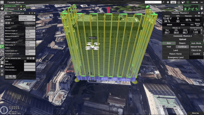
The new automatic Facade Scan tool of UgCS for drone inspection mission planning is a time and cost saver for construction, engineering and mining industries.
Various tools for surveying horizontal surfaces, even the uneven ones, have been developed to a high standard and are widely available on the market. Inspecting vertical surfaces is a completely different story — previously it required a lot of manual work and so was a burden for professional drone users. But now, with the autom
Klau Geomatics releases High Accuracy Real-Time Positioning for Surveying and Drone
By Lurker,
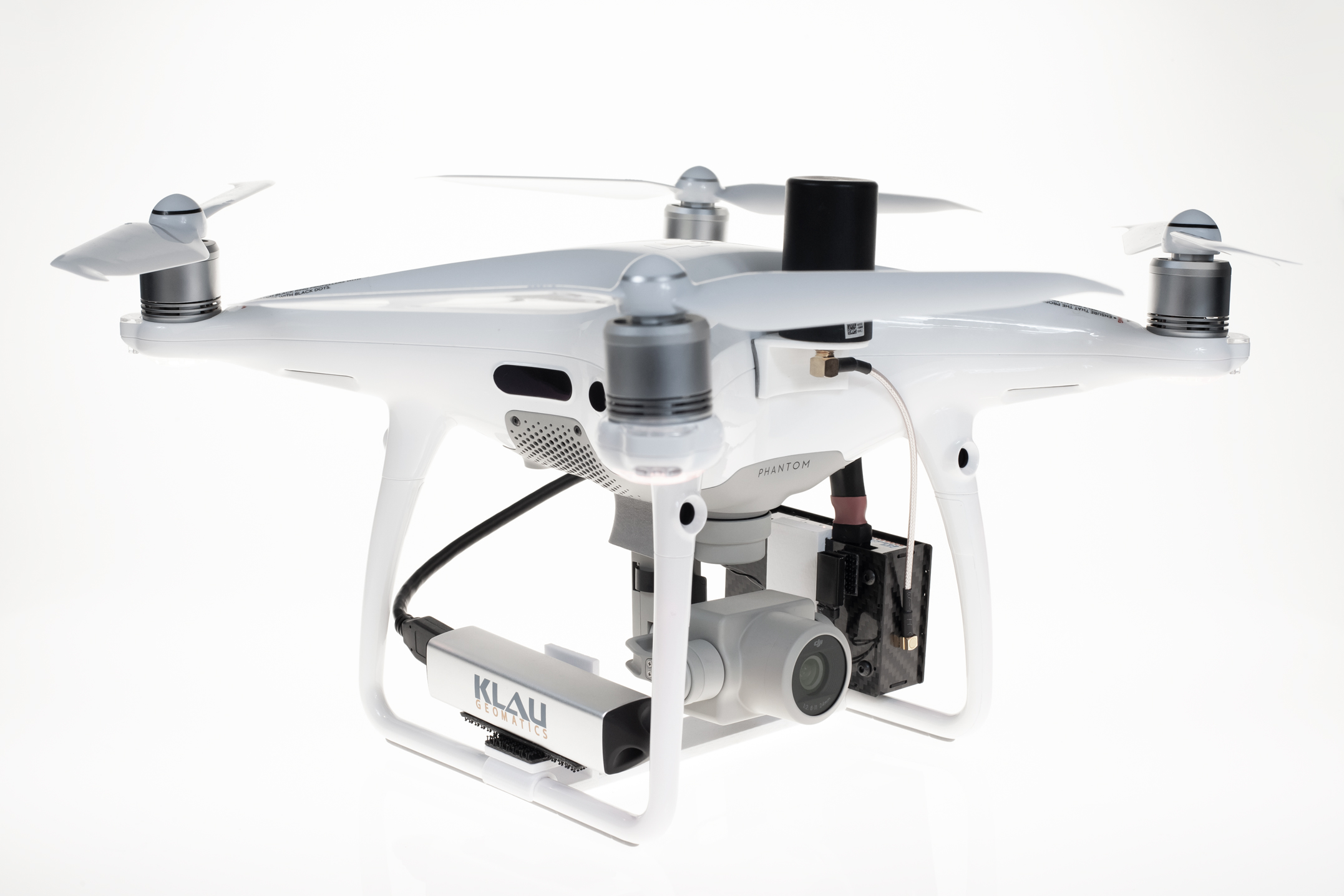
Klau Geomatics has released Real-Time Precise Point Positioning (PPP) for aerial mapping and drone positioning that enables 3 to 5 cm initial positioning accuracy, anywhere in the world, without any base station data or network corrections.
With this, you Just need to fly your drone at any distance, anywhere. The system allows to navigate with real-time cm level positioning or geotag your mapping photos and Lidar data.
You don’t need to think about setting up a base station, find
Galileo constellation add another 4 satellites
By Lurker,
The latest four Galileo satellites have been given the green light to begin working alongside the rest of Europe’s satellite navigation fleet, giving a further boost to worldwide Galileo service quality.
Galileo has grown to become Europe’s single largest satellite constellation, built up over 10 launches over the course of this decade. The first of seven double-satellite Soyuz launches took place in 2011, with three sets of four-satellite Ariane-5 launches during the last three years.
Airbus and Hisdesat process the first TerraSAR-X / PAZ Radar Interferogram
By Lurker,
Airbus Defence and Space and Hisdesat Servicios Estratégicos, S.A. have generated the first joint TerraSAR-X / PAZ Radar Interferogram. This milestone demonstrates the missions’ capacity for cross-sensor interferometry, whose processing is among the most challenging.
Interferograms are typically used to derive the topographic elevation and deformation of the Earth’s surface and are created using at least two different images acquired at a different date. This flattened Cross-Sensor-Interfer
-
Forum Statistics
8.8k
Total Topics43.5k
Total Posts
-
Latest Posts
-
-

-
 Are you ready to level up your geospatial skills? Join our comprehensive training course covering ArcMap, ArcGIS Pro, and ArcOnline—the essential tools for modern spatial analysis and programming! What You’ll Learn: Core functionalities of ArcMap & ArcGIS Pro Cloud-based mapping with ArcGIS Online Automating workflows with Python & ModelBuilder Creating interactive web maps & apps Who Should Enroll? GIS beginners & professionals Urban planners, environmental scientists, & data analysts Developers looking to integrate spatial programming Why Choose This Course? Hands-on projects & real-world applications Expert-led sessions & flexible learning Limited slots available! Click here to register. Let’s shape the future of spatial data together!
 -
GPS is an incredible piece of modern technology. Not only does it allow for locating objects precisely anywhere on the planet, but it also enables the turn-by-turn directions we take for granted these days — all without needing anything more than a radio receiver and some software to decode the signals constantly being sent down from space. [Chris] took that last bit bit as somewhat of a challenge and set off to write a software-defined GPS receiver from the ground up. As GPS started as a military technology, the level of precision needed for things like turn-by-turn navigation wasn’t always available to civilians. The “coarse” positioning is only capable of accuracy within a few hundred meters, so this legacy capability is the first thing that [Chris] tackles here. It is pretty fast, though, with the system able to resolve a location in 24 seconds from cold start and then displaying its information in a browser window. Everything in this build is done in Python as well, meaning that it’s a great starting point for investigating how GPS works and for building other projects from there. The other thing that makes this project accessible is that the only other hardware needed besides a computer that runs Python is an RTL-SDR dongle. These inexpensive TV dongles ushered in a software-defined radio revolution about a decade ago when it was found that they could receive a wide array of radio signals beyond just TV. source: Hackaday and GitHub - chrisdoble/gps-receiver
-
-
Latest Topics
-
-
Recent Achievements


