- 1 reply
- 1,247 views
- Add Reply
- 1 reply
- 1,918 views
- Add Reply
- 0 replies
- 1,143 views
- Add Reply
- 0 replies
- 1,958 views
- Add Reply
- 0 replies
- 1,177 views
- Add Reply
Nasa fire data

By intertronic,

You can download the Active Fire data (Nasa sensor-sensed fires) from this site :
https://firms.modaps.eosdis.nasa.gov/active_fire/#firms-shapefile
Satellites available : MODIS (AQUA + TERRA:1km), Suomi NPP (VIIRS:375m) and also NOAA20 (VIIRS :375m)
Data : as SHP / KML or CSV as a single files
for the last 24h/48h/7d/
and here putted on a map
https://firms.modaps.eosdis.nasa.gov/map/#z:3;c:110.9,10.8;d:2020-04-24..2020-04-25
(There is a lot of sit
swisstopo (Switzerland) GIS jobs
By intertronic,
6x open positions (as of 24.04.2020)
French site (simple put "GIS" or "Swisstopo" in the search area)
https://www.stelle.admin.ch/stelle/fr/home/stellen/stellenangebot.html
German
https://www.stelle.admin.ch/stelle/de/home/stellen/stellenangebot.html
GPS circle spoofing discovered in Iran

By Lurker,

In March, the U.S. government received an unusual inquiry about GPS disruptions. It was from a user in Iran reporting what appeared to be “circle spoofing” — a phenomenon that had only previously been observed in China.
“Some of GPS devices received fake signal and show the fake valid location. Yesterday I test a device, it can get signal and give real position. After 10 minutes the device show moving around a big circle in tehran by 35 km/h speed. I can’t fix this problem by restarting the
USGS releases first-ever comprehensive geologic map of the Moon
By Lurker,
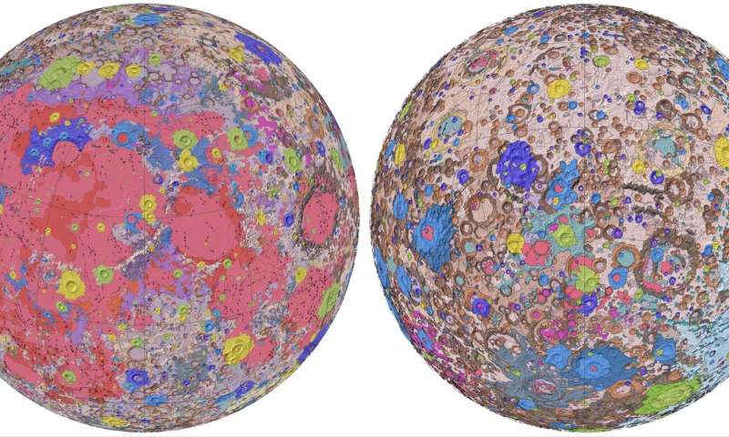
Have you ever wondered what kind of rocks make up those bright and dark splotches on the moon? Well, the USGS has just released a new authoritative map to help explain the 4.5-billion-year-old history of our nearest neighbor in space.
For the first time, the entire lunar surface has been completely mapped and uniformly classified by scientists from the USGS, in collaboration with NASA and the Lunar Planetary Institute.
The lunar map, called the "Unified Geologic Map of the Moon," will
What unit of measurement is rxwaveform from the gedi l1b dataset in?

By bwoods,
Rxwaveform is listed in GEDI's data level product L1B's data dictionary as "The corrected receive (RX) waveforms. Use rx_sample_count and rx_sample_start_index to identify the location of each waveform. " This can also be seen in the attached image. I understand that waveforms are typically measured by amplitude as a function of time(or height), but are the values listed in rxwaveforms amplitudes? It doesn't explicitly say amplitude in the data dictionary, and what unit of measurement is amplitu
-
Forum Statistics
8.8k
Total Topics43.5k
Total Posts
-
Latest Posts
-
-

-
 Are you ready to level up your geospatial skills? Join our comprehensive training course covering ArcMap, ArcGIS Pro, and ArcOnline—the essential tools for modern spatial analysis and programming! What You’ll Learn: Core functionalities of ArcMap & ArcGIS Pro Cloud-based mapping with ArcGIS Online Automating workflows with Python & ModelBuilder Creating interactive web maps & apps Who Should Enroll? GIS beginners & professionals Urban planners, environmental scientists, & data analysts Developers looking to integrate spatial programming Why Choose This Course? Hands-on projects & real-world applications Expert-led sessions & flexible learning Limited slots available! Click here to register. Let’s shape the future of spatial data together!
 -
GPS is an incredible piece of modern technology. Not only does it allow for locating objects precisely anywhere on the planet, but it also enables the turn-by-turn directions we take for granted these days — all without needing anything more than a radio receiver and some software to decode the signals constantly being sent down from space. [Chris] took that last bit bit as somewhat of a challenge and set off to write a software-defined GPS receiver from the ground up. As GPS started as a military technology, the level of precision needed for things like turn-by-turn navigation wasn’t always available to civilians. The “coarse” positioning is only capable of accuracy within a few hundred meters, so this legacy capability is the first thing that [Chris] tackles here. It is pretty fast, though, with the system able to resolve a location in 24 seconds from cold start and then displaying its information in a browser window. Everything in this build is done in Python as well, meaning that it’s a great starting point for investigating how GPS works and for building other projects from there. The other thing that makes this project accessible is that the only other hardware needed besides a computer that runs Python is an RTL-SDR dongle. These inexpensive TV dongles ushered in a software-defined radio revolution about a decade ago when it was found that they could receive a wide array of radio signals beyond just TV. source: Hackaday and GitHub - chrisdoble/gps-receiver
-
-
Latest Topics
-
-
Recent Achievements


