- 0 replies
- 2,290 views
- Add Reply
- 2 replies
- 4,542 views
- Add Reply
- 4 replies
- 4,668 views
- Add Reply
- 1 reply
- 1,831 views
- Add Reply
- 0 replies
- 3,387 views
- Add Reply
DJI Matrice 300 RTK drone: 55-minute flight time, Zenmuse cameras

By Lurker,

Stop me if you’ve heard this before. DJI has introduced its latest enterprise powerhouse drone, the DJI Matrice 300 RTK. We learned a lot about the drone earlier this week due to a few huge leaks of specs, features, photos, and videos. But it’s worth looking at the drone again now that it’s official – and an incredible intro video.
Also called the M300 RTK, this drone is an upgrade in every way over its predecessor, the M200 V2. That includes a very long flight time of 55 minutes, six-direc
Metadata in QGIS 2.x issue

By darksabersan,
Hi guys,
Since a very long on ArcGIS, I am used to use Metadata to goes along with my data, like Shapefile, GDB, etc. I add all king of usefull informations that I can provide to it.
Using QGIS 3.x is definitely not a hard job regarding Metadata because they are store into a *.qmd file and this works very fine.
I am much more trouble to use QGIS 2.x because there is the Metadata tab into the layer properties but I am unable to make it work. I mean, I can't see any *.xml file and w
DJI Mavic Air 2 Is a Sleeker and Longer-Flying Drone
By Lurker,

DRONE MAKER DJI announced an update to its popular Mavic Air quadcopter today. The Mavic Air 2 will cost $799 when it ships to US buyers in late May. That's the same price as the previous Mavic Air model, so the drone stays as DJI's mid-range option between its more capable Mavic 2 and its smaller, cheaper Mavic Mini.
The Mavic Air 2 is still plenty small, but the new version has put on some weight. DJI says that testing and consumer surveys suggested that most people don't mind lugging a f
Interactive Dinosaur Database and Map
By Lurker,
Interesting application of WebGIS to plot Dinosaur database, and you can search how is your place in the past on the interactive globe Map.
Welcome to the internet's largest dinosaur database. Check out a random dinosaur, search for one below, or look at our interactive globe of ancient Earth!
Whether you are a kid, student, or teacher, you'll find a rich set of dinosaur names, pictures, and facts here. This site is built with PaleoDB, a scientific database assembled by hundreds of pal
EarthNow - almost live landsat

By intertronic,
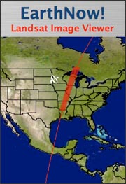
such a cool site (just for fun):
Watch as Landsat Data Are Collected
T
he U.S. Geological Survey (USGS) has made it possible for you to watch as swaths of data from the Landsat 5 and Landsat 7 satellites are collected and downloaded to the USGS Center for Earth Resources Observation and Science (EROS) in Sioux Falls, SD.
USGS EarthNow! displays data received from the Landsat 5 and Landsat 7 satellites as they pass over the U
-
Forum Statistics
8.8k
Total Topics43.5k
Total Posts
-
Latest Posts
-
-

-
 Are you ready to level up your geospatial skills? Join our comprehensive training course covering ArcMap, ArcGIS Pro, and ArcOnline—the essential tools for modern spatial analysis and programming! What You’ll Learn: Core functionalities of ArcMap & ArcGIS Pro Cloud-based mapping with ArcGIS Online Automating workflows with Python & ModelBuilder Creating interactive web maps & apps Who Should Enroll? GIS beginners & professionals Urban planners, environmental scientists, & data analysts Developers looking to integrate spatial programming Why Choose This Course? Hands-on projects & real-world applications Expert-led sessions & flexible learning Limited slots available! Click here to register. Let’s shape the future of spatial data together!
 -
GPS is an incredible piece of modern technology. Not only does it allow for locating objects precisely anywhere on the planet, but it also enables the turn-by-turn directions we take for granted these days — all without needing anything more than a radio receiver and some software to decode the signals constantly being sent down from space. [Chris] took that last bit bit as somewhat of a challenge and set off to write a software-defined GPS receiver from the ground up. As GPS started as a military technology, the level of precision needed for things like turn-by-turn navigation wasn’t always available to civilians. The “coarse” positioning is only capable of accuracy within a few hundred meters, so this legacy capability is the first thing that [Chris] tackles here. It is pretty fast, though, with the system able to resolve a location in 24 seconds from cold start and then displaying its information in a browser window. Everything in this build is done in Python as well, meaning that it’s a great starting point for investigating how GPS works and for building other projects from there. The other thing that makes this project accessible is that the only other hardware needed besides a computer that runs Python is an RTL-SDR dongle. These inexpensive TV dongles ushered in a software-defined radio revolution about a decade ago when it was found that they could receive a wide array of radio signals beyond just TV. source: Hackaday and GitHub - chrisdoble/gps-receiver
-
-
Latest Topics
-
-
Recent Achievements


