- 0 replies
- 829 views
- Add Reply
- 0 replies
- 770 views
- Add Reply
- 0 replies
- 1,062 views
- Add Reply
- 3 replies
- 2,501 views
- Add Reply
- 0 replies
- 1,656 views
- Add Reply
Rocket Lab acquires Sinclair Interplanetary

By Lurker,

The US firm and its New Zealand subsidiary is the maker of the Electron launch vehicle and Photon line of primarily Low Earth Orbit satellites, which the acquisition of Sinclair’s capabilities will significantly bolster.
The move appears to be a major plank in Rocket Lab’s strategy to provide end-to-end launch and small satellite services, according to Peter Beck, Rocket Lab founder and CEO.
“When we talk to small satellite operators across the board their challenges are clear: They ne
New UAVOS parachute system for UAS
By Lurker,
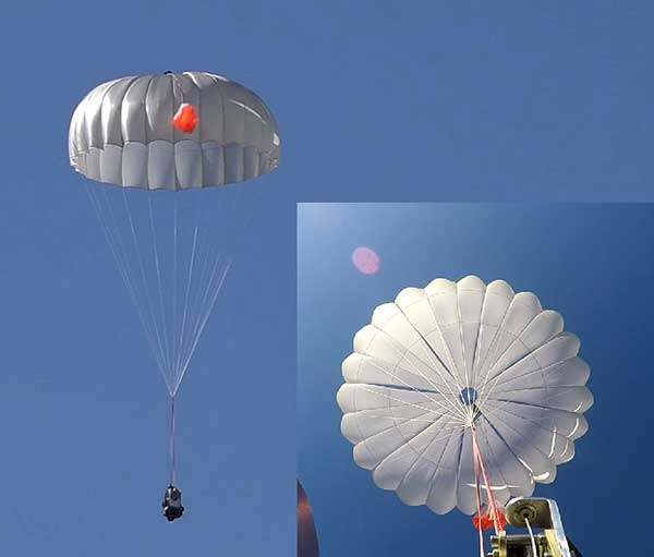
UAVOS has successfully tested its new two-stage parachute system. The new parachute system provides slow descent of a UAS at high speed. It includes two parachutes — the pilot chute and a main chute used to slow and stabilize the UAS.
The decrease in the load speed on the UAS occurs due to the main chute opening delay function, when the pilot chute opens first. The parachute system is designed for UAS with speeds of up to 280 mph (450 kph) and weight of up to 110 lb (50 kg).
Watch the
SPH Engineering announces bathymetric drone solution
By Lurker,
SPH Engineering has launched a new product to make bathymetric surveys of inland and coastal water.
The system — an unmanned aerial vehicle (UAV) integrated with an echo sounder — is time- and cost-efficient. It is suitable for mapping, measuring and inspecting tasks as well as environmental monitoring.
The system allows field workers to collect data with high accuracy quickly. It is easily transported, quickly deployed and twice as cost-efficient as traditional methods.
The UAV/e
Skytraq PX1122R Tiny Multi-Band RTK GNSS Module Offers Centimeter Accuracy
By Lurker,

Several years ago Skytraq introduced NavSpark mini, a tiny (17x17mm) GPS module, that sold for $6. I got one and wrote a post explaining how to get started with the GPS module using GNSS viewer program.
The company contacted me again today, as they’ve now launched an even smaller module Skytraq PX1122R measuring just 16x12mm, supporting GPS, Galileo, GLONASS, and Beidou signals, as well as Real-time Kinematic (RTK) relative positioning technique that allows for 1-3cm positionin
Tutorial Basic GRASS with BASH in LInux
By Lurker,
GRASS GIS was, for a long time, something I dismissed as ‘too complex’ for my everyday geospatial operations. I formulated any number of excuses to work around the software and could not be convinced it had practical use in my daily work. It was ‘too hard to set-up’, ‘never worked well with QGIS’, and ‘made my scripting processes a nightmare’.
In this example we will:
part 1:
1. Download a small piece of elevation data from the LINZ Data Service
2. Build a GRASS environment to p
-
Forum Statistics
8.8k
Total Topics43.5k
Total Posts
-
Latest Posts
-

-
 Are you ready to level up your geospatial skills? Join our comprehensive training course covering ArcMap, ArcGIS Pro, and ArcOnline—the essential tools for modern spatial analysis and programming! What You’ll Learn: Core functionalities of ArcMap & ArcGIS Pro Cloud-based mapping with ArcGIS Online Automating workflows with Python & ModelBuilder Creating interactive web maps & apps Who Should Enroll? GIS beginners & professionals Urban planners, environmental scientists, & data analysts Developers looking to integrate spatial programming Why Choose This Course? Hands-on projects & real-world applications Expert-led sessions & flexible learning Limited slots available! Click here to register. Let’s shape the future of spatial data together!
 -
GPS is an incredible piece of modern technology. Not only does it allow for locating objects precisely anywhere on the planet, but it also enables the turn-by-turn directions we take for granted these days — all without needing anything more than a radio receiver and some software to decode the signals constantly being sent down from space. [Chris] took that last bit bit as somewhat of a challenge and set off to write a software-defined GPS receiver from the ground up. As GPS started as a military technology, the level of precision needed for things like turn-by-turn navigation wasn’t always available to civilians. The “coarse” positioning is only capable of accuracy within a few hundred meters, so this legacy capability is the first thing that [Chris] tackles here. It is pretty fast, though, with the system able to resolve a location in 24 seconds from cold start and then displaying its information in a browser window. Everything in this build is done in Python as well, meaning that it’s a great starting point for investigating how GPS works and for building other projects from there. The other thing that makes this project accessible is that the only other hardware needed besides a computer that runs Python is an RTL-SDR dongle. These inexpensive TV dongles ushered in a software-defined radio revolution about a decade ago when it was found that they could receive a wide array of radio signals beyond just TV. source: Hackaday and GitHub - chrisdoble/gps-receiver
-
-
-
Latest Topics
-
-
Recent Achievements


