- 0 replies
- 1,157 views
- Add Reply
- 0 replies
- 955 views
- Add Reply
- 3 replies
- 2,955 views
- Add Reply
- 5 replies
- 2,331 views
- Add Reply
- 0 replies
- 1,243 views
- Add Reply
CHC Navigation introduces AT661 GNSS geodetic antenna

By Lurker,

CHC Navigation has released the AT661 geodetic antenna for GNSS networks or monitoring applications. The AT GNSS antenna series is the result of years of expertise in GNSS technologies. The compact geodetic GNSS antenna offers performances rivaling those of high-cost and bulky conventional GNSS choke ring antennas, according to CHC Navigation.
The AT661’s supports all current and future GNSS signals, including GPS, GLONASS, BeiDou, Galileo, QZSS, IRNSS, SBAS and L-band. The antenna features
We will need to perform GNSS occupations as part of a leveling project after 2022
By Lurker,
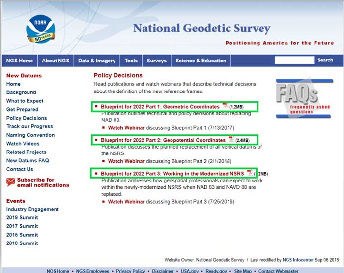
This column will address why users will be required to perform GNSS occupations when submitting a leveling project to the National Geodetic Survey (NGS) after 2022. It will highlight a section of NGS Blueprint for 2022, Part 3, “Working in the Modernized NSRS,” that discusses the process of performing leveling projects after 2022. My October 2017 column briefly discussed NGS’ preliminary plans for incorporating geodetic leveling data into the North American-Pacific Geopotential Datum of 2022 (NA
10 New ArcGIS Pro Lesson Activities, Learn Paths, and Migration Reflections
By Lurker,
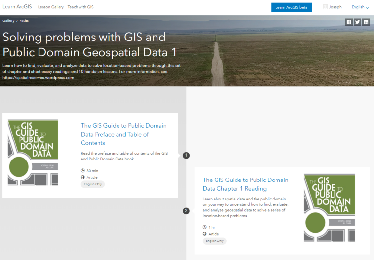
A new set of 10 ArcGIS Pro lessons empowers GIS practitioners, instructors, and students with essential skills to find, acquire, format, and analyze public domain spatial data to make decisions. Described in this video, this set was created for 3 reasons: (1) to provide a set of analytical lessons that can be immediately used, (2) to update the original 10 lessons created by my colleague Jill Clark and I to provide a practical component to our Esri Press book The GIS Guide to Public Domain Dat
NASADEM: Creating a New NASA Digital Elevation Model and Associated Products
By Lurker,
Our objective is to provide the scientific and civil communities with a state-of-the-art global digital elevation model (DEM) derived from a combination of Shuttle Radar Topography Mission (SRTM) processing improvements, elevation control, void-filling and merging with data unavailable at the time of the original SRTM production:
NASA SRTM DEMs created with processing improvements at full resolution
NASA's Ice, Cloud,and land Elevation Satellite (ICESat)/Geoscience Laser Altimeter
Veripos release LD900 quad-band GNSS receiver for marine
By Lurker,
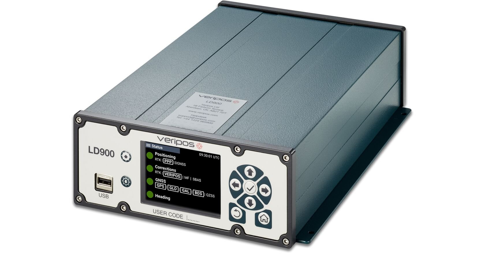
Veripos has released the LD900, a quad-band GNSS receiver capable of tracking GPS, GLONASS, BeiDou, Galileo and QZSS constellations to provide reliable and accurate positioning. Access to multiple GNSS signals allow for better satellite availability and reduce the impact of satellite masking or blockage, which can affect positioning.
LD900 also receives L-band signals on multiple channels, providing access to the worldwide independent correction links and services provided by Veripos. With
-
Forum Statistics
8.8k
Total Topics43.5k
Total Posts
-
Latest Posts
-

-
 Are you ready to level up your geospatial skills? Join our comprehensive training course covering ArcMap, ArcGIS Pro, and ArcOnline—the essential tools for modern spatial analysis and programming! What You’ll Learn: Core functionalities of ArcMap & ArcGIS Pro Cloud-based mapping with ArcGIS Online Automating workflows with Python & ModelBuilder Creating interactive web maps & apps Who Should Enroll? GIS beginners & professionals Urban planners, environmental scientists, & data analysts Developers looking to integrate spatial programming Why Choose This Course? Hands-on projects & real-world applications Expert-led sessions & flexible learning Limited slots available! Click here to register. Let’s shape the future of spatial data together!
 -
GPS is an incredible piece of modern technology. Not only does it allow for locating objects precisely anywhere on the planet, but it also enables the turn-by-turn directions we take for granted these days — all without needing anything more than a radio receiver and some software to decode the signals constantly being sent down from space. [Chris] took that last bit bit as somewhat of a challenge and set off to write a software-defined GPS receiver from the ground up. As GPS started as a military technology, the level of precision needed for things like turn-by-turn navigation wasn’t always available to civilians. The “coarse” positioning is only capable of accuracy within a few hundred meters, so this legacy capability is the first thing that [Chris] tackles here. It is pretty fast, though, with the system able to resolve a location in 24 seconds from cold start and then displaying its information in a browser window. Everything in this build is done in Python as well, meaning that it’s a great starting point for investigating how GPS works and for building other projects from there. The other thing that makes this project accessible is that the only other hardware needed besides a computer that runs Python is an RTL-SDR dongle. These inexpensive TV dongles ushered in a software-defined radio revolution about a decade ago when it was found that they could receive a wide array of radio signals beyond just TV. source: Hackaday and GitHub - chrisdoble/gps-receiver
-
-
-
Latest Topics
-
-
Recent Achievements


