- 0 replies
- 1,834 views
- Add Reply
- 0 replies
- 935 views
- Add Reply
- 0 replies
- 1,139 views
- Add Reply
- 3 replies
- 9,888 views
- Add Reply
- 0 replies
- 1,097 views
- Add Reply
Remote Sensing uncover widespread illegal fishing in Pacific Ocean

By Lurker,
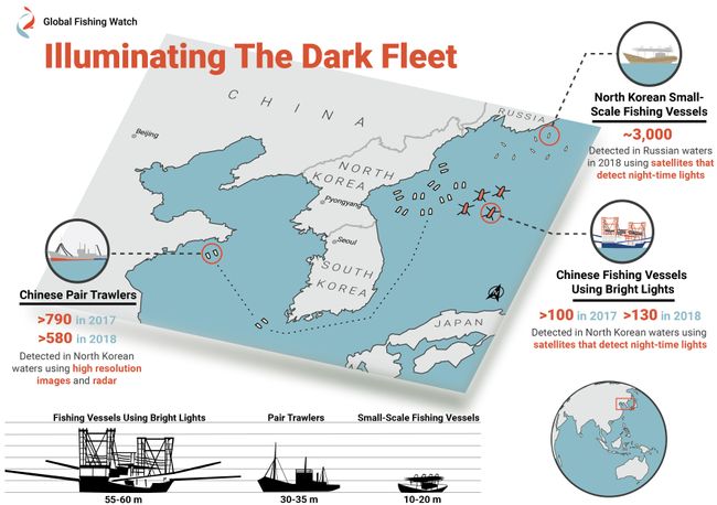
Scofflaw ships hauled in more than 176,000 tons of Pacific flying squid in North Korean waters in 2017 and 2018.
A 55- to 60-meter lighting vessel of Chinese origin near North Korean waters. This vessel had its four arm-like structures deployed and flew both North Korean and Chinese flags.
Satellite imagery has dragged "dark" fishing fleets out into the light.
Orbital observations have revealed extensive illegal fishing of Pacific flying squid (Todarodes pacificus) i
Marine Species are Shifting Towards the Poles
By Lurker,

Global warming has caused a shift in species’ ideal habitats, prompting everything from mushrooms to trees, mammals to amphibians and other terrestrial species to seek out different ecological zones in which to thrive. New research is collecting data on marine species that are also experiencing climate related habitat migrations in greater numbers than scientists anticipated.
As species’ normal habitats are becoming warmer, habitat is lost due to human infrastructure, or habitats are becomi
UrsaNav installs eLoran testbed in South Korea
By Lurker,
South Korean is in the early stages of evaluating its eLoran system, but great results are expected based on the UrsaNav-supplied station in Incheon.
In August 2018, the Korea Research Institute of Ships and Oceans Engineering (KRISO) awarded UrsaNav, through its agent Dong Kang M-Tech, a contract to supply and install an eLoran transmitter testbed system in South Korea. UrsaNav is the exclusive, worldwide distributor of Nautel’s NL Series transmitters, provided eLoran transmitter tec
Create Interactive Flow Maps
By Lurker,

Flow maps are cartographic visualizations to show the movement of objects, people, or other living things from one location to another. Lines, usually symbolized with an arrow to indicate the direction. Color coding or line width can also then be used to indicate the volume of objects that are moving from one location to another. Airline traffic, animal migration, commuters, and import/exports are all common types of geographic data that are typically shown on a flow map .
Ilya Boyandin has
Eos Positioning Systems releases Eos Tools Pro for Windows
By Lurker,
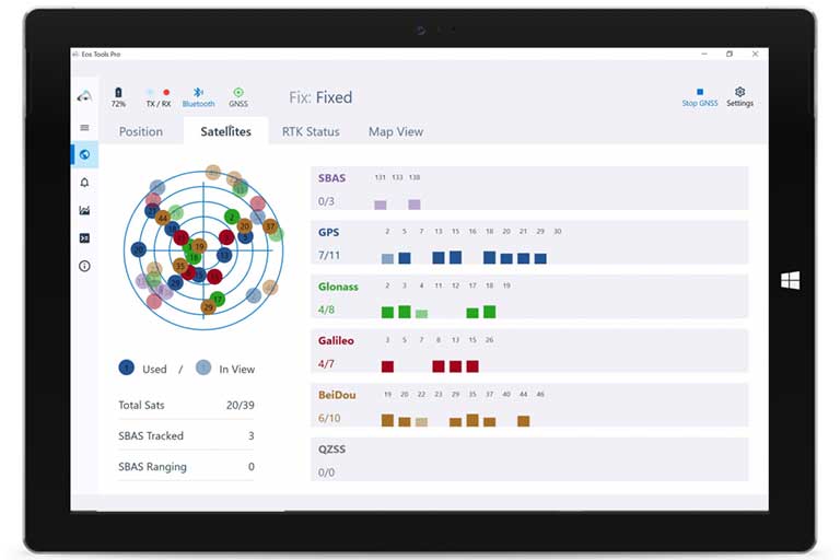
Eos Positioning Systems — manufacturer of Arrow Series GNSS receivers — has released Eos Tools Pro for Windows 10.
Eos Tools Pro implements powerful new features that enables users to exploit all four global GNSS constellations and a state-of-the-art NTRIP client to access real-time kinematic (RTK) bases and RTK networks all over the world via NTRIP, Direct IP and wireless radios.
“This is a huge step forward in functionality and flexibility for our Windows users,” said Jean-Yves Lautu
-
Forum Statistics
8.8k
Total Topics43.5k
Total Posts
-
Latest Posts
-
 Are you ready to level up your geospatial skills? Join our comprehensive training course covering ArcMap, ArcGIS Pro, and ArcOnline—the essential tools for modern spatial analysis and programming! What You’ll Learn: Core functionalities of ArcMap & ArcGIS Pro Cloud-based mapping with ArcGIS Online Automating workflows with Python & ModelBuilder Creating interactive web maps & apps Who Should Enroll? GIS beginners & professionals Urban planners, environmental scientists, & data analysts Developers looking to integrate spatial programming Why Choose This Course? Hands-on projects & real-world applications Expert-led sessions & flexible learning Limited slots available! Click here to register. Let’s shape the future of spatial data together!
 -
GPS is an incredible piece of modern technology. Not only does it allow for locating objects precisely anywhere on the planet, but it also enables the turn-by-turn directions we take for granted these days — all without needing anything more than a radio receiver and some software to decode the signals constantly being sent down from space. [Chris] took that last bit bit as somewhat of a challenge and set off to write a software-defined GPS receiver from the ground up. As GPS started as a military technology, the level of precision needed for things like turn-by-turn navigation wasn’t always available to civilians. The “coarse” positioning is only capable of accuracy within a few hundred meters, so this legacy capability is the first thing that [Chris] tackles here. It is pretty fast, though, with the system able to resolve a location in 24 seconds from cold start and then displaying its information in a browser window. Everything in this build is done in Python as well, meaning that it’s a great starting point for investigating how GPS works and for building other projects from there. The other thing that makes this project accessible is that the only other hardware needed besides a computer that runs Python is an RTL-SDR dongle. These inexpensive TV dongles ushered in a software-defined radio revolution about a decade ago when it was found that they could receive a wide array of radio signals beyond just TV. source: Hackaday and GitHub - chrisdoble/gps-receiver
-
-

-
-
Latest Topics
-
-
Recent Achievements


