- 2 replies
- 3,589 views
- Add Reply
- 0 replies
- 2,954 views
- Add Reply
- 0 replies
- 2,695 views
- Add Reply
- 5 replies
- 5,100 views
- Add Reply
- 0 replies
- 2,599 views
- Add Reply
Scribble Maps Pro

By EmperoR,


There are many online applications available that encourage the creation, usage, and sharing of maps among professionals, classmates, and friends. Scribble Maps Pro is one that not only targets both the novice and expert map creator, but unlike its similar counterpart Google Earth Pro, it doesn’t require any special downloads - and it’s free. Its ease of use and accessibility makes it one of the most popular applications in the education sector, offering users a wide range of capabilities, such
Geocontext-Profiler

By EmperoR,
Program Geocontext-Profiler allows you to make topographic profiles anywhere on Earth in the seabed and ocean floor. Can be widely used: in the natural sciences (geomorphology, hydrography) for the education and tourism – hiking route planning, bicycle, car. To create such a profile, a few simple steps:
1. Reset
2. Find your area of interest on the map
3. Select the cursor min. 2 points (max. 33).
[no limit]
* Enabling this option will: that you can not keep a
MOVED: GIS apps for Android?

By Lurker,
This topic has been moved to Request and Troubleshooting Area.
[iurl]http://gisarea.com/index.php?topic=563.0[/iurl]
ArcPad Tips and Trick

By EmperoR,


I compile some tips and trick bout arcpad , enjoy mate :kiss:
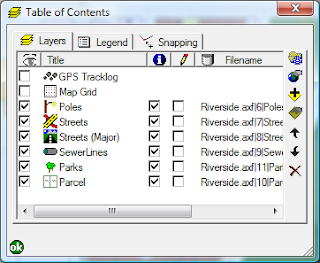
ArcPad Tips & Tricks #1: Layer Icons
Did you know that you can set icons for your layers. These will appear in the Table of Contents and the Edit drop down menu, making it easier to differentiate between your layers.
For shapefiles, all you need to do is copy a .ico file, with the same base name as the shapefile, into the same directory. So, for example, if your shapefile is Roads.shp, name you .ico file Roads.ico.
The
J2ME and Location-Based Services

By EmperoR,
Location-based services (LBS) provide users of mobile devices personalized services tailored to their current location. They open a new market for developers, cellular network operators, and service providers to develop and deploy value-added services: advising users of current traffic conditions, supplying routing information, helping them find nearby restaurants, and many more.
This article introduces you to the field of LBS and to the Location API for J2ME (JSR 179), a set of generic APIs t
-
Forum Statistics
8.7k
Total Topics43.5k
Total Posts


