- 0 replies
- 1,843 views
- Add Reply
- 0 replies
- 3,012 views
- Add Reply
- 1 reply
- 1,169 views
- Add Reply
- 1 reply
- 1,007 views
- Add Reply
- 0 replies
- 1,106 views
- Add Reply
Latest satellite images show situation far from normal at Ladakh's Pangong Tso

By Lurker,

Despite the controversy related to China-India border, this articles show us the importance of Remote Sensing as a strategic tools on Politic and Military
The recent deaths of at least 20 soldiers along the contested border at Ladakh between India and China represents the largest loss of life from a skirmish between the two countries since the clashes in 1967 that left hundreds dead. It also highlights the tensions that have been building along the Line of Actual
Google Releases Google Maps CarPlay Feature for Testers
By Lurker,

This is without a doubt the most anticipated feature of the year for CarPlay users, as Google Maps can now replace Apple Maps on the multi-view screen.
Apple originally locked the maps card on the CarPlay dashboard to Apple Maps, which means that users weren’t allowed to configure any other application to display real-time information in this panel.
It goes without saying this was quite an issue for many users, especially as Google Maps and the Google-owned Waze are extremely popular c
GPS reveals volcanic activity under Europe
By Lurker,

Scientists have discovered new evidence for active volcanism next door to some of the most densely populated areas of Europe. The study crowdsourced GPS monitoring data from antennae across western Europe to track subtle movements in the Earth’s surface, thought to be caused by a rising subsurface mantle plume.
The Eifel region lies roughly between the cities of Aachen, Trier and Koblenz, in west-central Germany. It is home to many ancient volcanic features, including the circular lakes kno
NASA launched 'Perseverance' to seek ancient life on Mars

By rahmansunbeam,
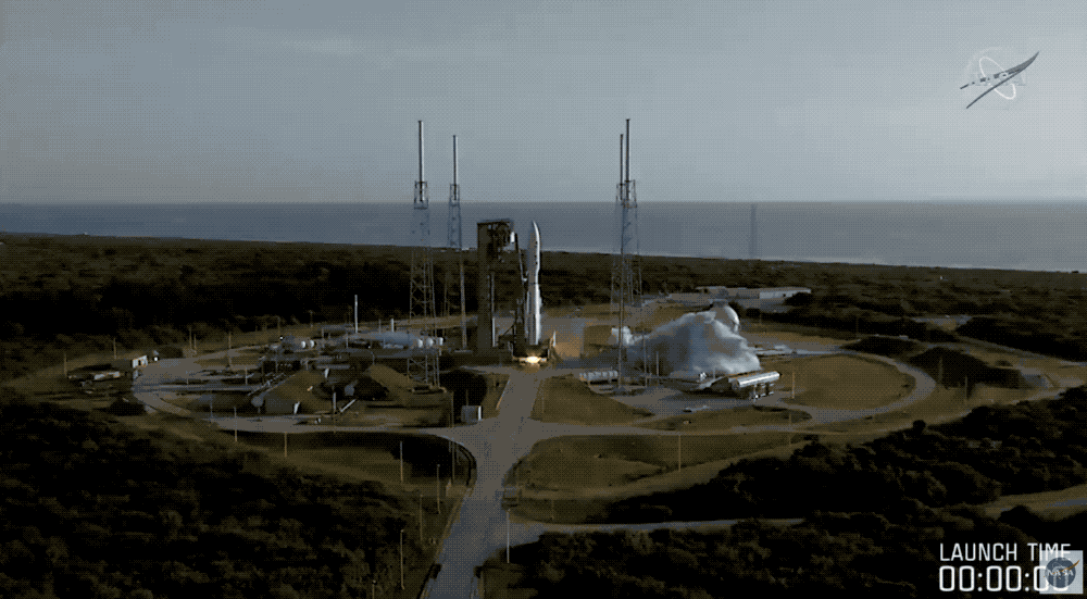
NASA has launched one of its most crucial science missions to date, the Mars 2020 mission that carries its Perseverance robotic rover. This rover, a successor to the Curiosity robotic explorer, is equipped with sensors specifically designed to help it hopefully fund evidence of ancient, microbiotic life on Mars.
Mars 2020 departed from Cape Canaveral in Florida at 7:50 AM EDT (4:50 PM PDT). Perseverance was loaded atop a United Launch Alliance (ULA) Atlas V rocket, which had a good liftoff
Historic carbon dioxide decline could hold clues for future climate
By Lurker,
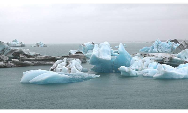
A new study led by researchers at The Australian National University (ANU) provides a clearer snapshot of conditions during the last ice age—when global ice sheets were at their peak—and could even lead to better models for future climate projections.
The study demonstrates a new way of recreating ocean conditions in the Atlantic during the Last Glacial Maximum (LGM)—around 20,000 years ago.
Lead author Dr. Jimin Yu says scientists have been trying to reconstruct ocean ci
-
Forum Statistics
8.8k
Total Topics43.5k
Total Posts
-
Latest Posts
-
 Are you ready to level up your geospatial skills? Join our comprehensive training course covering ArcMap, ArcGIS Pro, and ArcOnline—the essential tools for modern spatial analysis and programming! What You’ll Learn: Core functionalities of ArcMap & ArcGIS Pro Cloud-based mapping with ArcGIS Online Automating workflows with Python & ModelBuilder Creating interactive web maps & apps Who Should Enroll? GIS beginners & professionals Urban planners, environmental scientists, & data analysts Developers looking to integrate spatial programming Why Choose This Course? Hands-on projects & real-world applications Expert-led sessions & flexible learning Limited slots available! Click here to register. Let’s shape the future of spatial data together!
 -
GPS is an incredible piece of modern technology. Not only does it allow for locating objects precisely anywhere on the planet, but it also enables the turn-by-turn directions we take for granted these days — all without needing anything more than a radio receiver and some software to decode the signals constantly being sent down from space. [Chris] took that last bit bit as somewhat of a challenge and set off to write a software-defined GPS receiver from the ground up. As GPS started as a military technology, the level of precision needed for things like turn-by-turn navigation wasn’t always available to civilians. The “coarse” positioning is only capable of accuracy within a few hundred meters, so this legacy capability is the first thing that [Chris] tackles here. It is pretty fast, though, with the system able to resolve a location in 24 seconds from cold start and then displaying its information in a browser window. Everything in this build is done in Python as well, meaning that it’s a great starting point for investigating how GPS works and for building other projects from there. The other thing that makes this project accessible is that the only other hardware needed besides a computer that runs Python is an RTL-SDR dongle. These inexpensive TV dongles ushered in a software-defined radio revolution about a decade ago when it was found that they could receive a wide array of radio signals beyond just TV. source: Hackaday and GitHub - chrisdoble/gps-receiver
-
-

-
-
Latest Topics
-
-
Recent Achievements


