- 1 reply
- 2,182 views
- Add Reply
- 0 replies
- 1,453 views
- Add Reply
- 0 replies
- 1,763 views
- Add Reply
- 0 replies
- 1,416 views
- Add Reply
- 0 replies
- 996 views
- Add Reply
SkySats 19-21 to Launch on SpaceX Falcon 9 Rideshare Mission

By Lurker,

Planet is set to launch three more new SkySats (SkySats 19-21) into Low Earth Orbit on August 18th (date subject to change), rounding out the fleet of SkySats already in operations and joining SkySats 16-18 that successfully launched aboard the SpaceX Falcon 9 in June.
Planet SkySats 1-15 operate in Sun Synchronous Orbits, a specific type of Low Earth Orbit that results in the Earth’s surface always being illuminated by the Sun at the same angle when the satellite is capturing imagery. Half
NASA Advanced Rapid Imaging Satellite Maps Blast Damage: Beirut Explosion Aftermath
By Lurker,
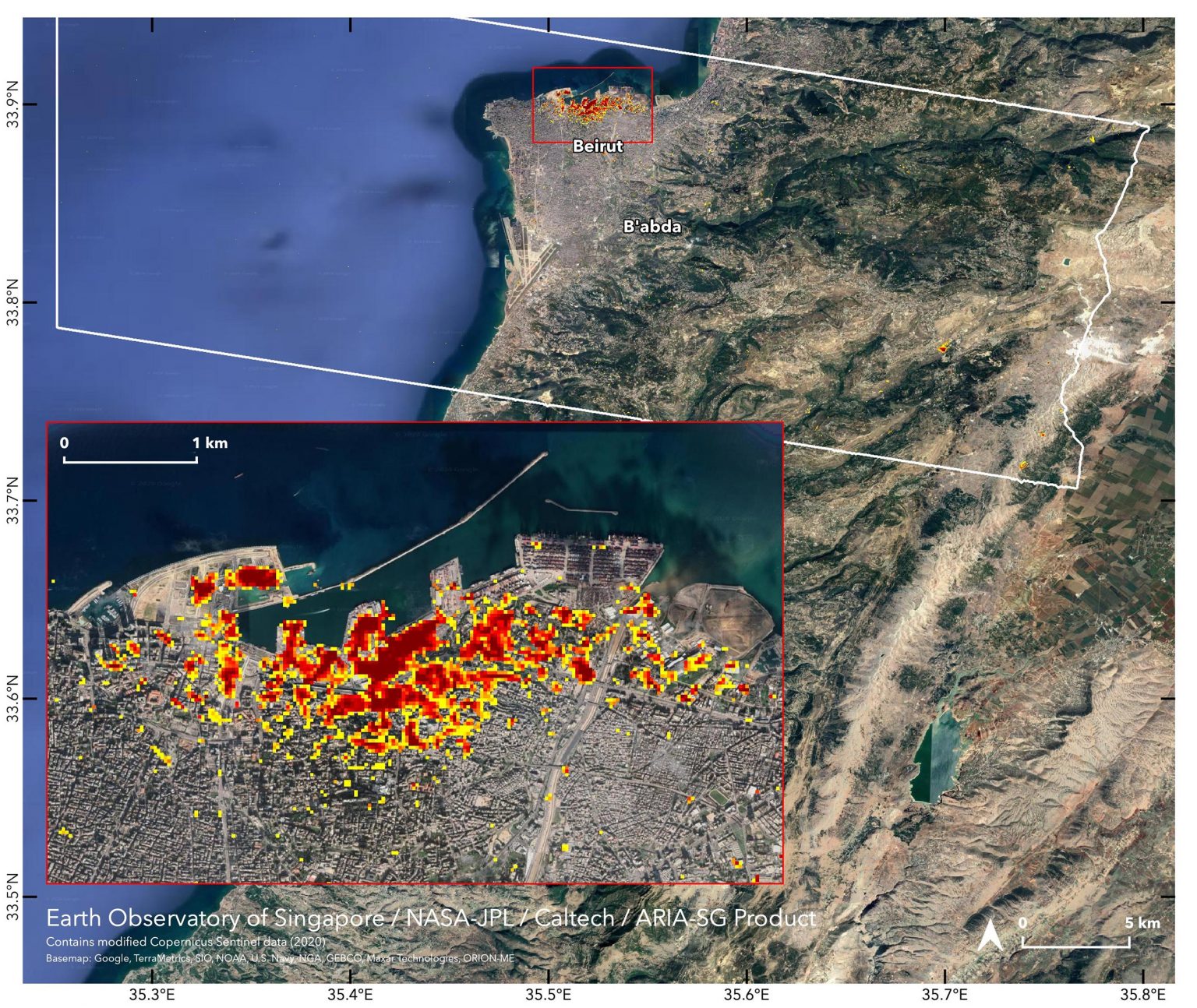
NASA’s ARIA team, in collaboration with the Earth Observatory of Singapore, used satellite data to map the extent of likely damage following a massive explosion in Beirut. Dark red pixels represent the most severe damage. Areas in orange are moderately damaged, and areas in yellow are likely to have sustained somewhat less damage. Each colored pixel represents an area of 30 meters (33 yards). The map contains modified Copernicus Sentinel data processed by ESA (European Space Agency) and analyzed
China launches new optical remote-sensing satellite
By Lurker,
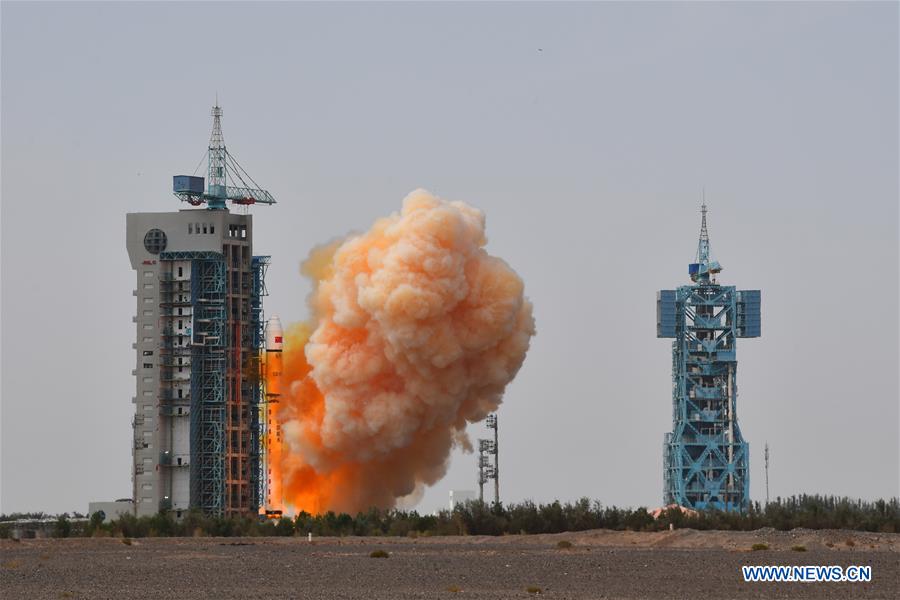
A Long March-2D carrier rocket, carrying the Gaofen-9 04 satellite, is launched from the Jiuquan Satellite Launch Center in northwest China, Aug. 6, 2020. China successfully launched a new optical remote-sensing satellite from the Jiuquan Satellite Launch Center at 12:01 p.m. Thursday (Beijing Time). (Photo by Wang Jiangbo/Xinhua)
JIUQUAN, Aug. 6 (Xinhua) -- China successfully launched a new optical remote-sensing satellite from the Jiuquan Satellite Launch Center in northwest China at 12:0
3D simulation

By iron1maiden,

The video shows a landslide analysis of Tersun Dam simulated with FLOW-3D. For more examples of how FLOW-3D can be used to analyze the catastrophic events. A fully 3D simulation was performed in the vicinity of the breach to capture the complex 3D hydraulic conditions.
https://www.youtube.com/watch?time_continue=3&v=f9QzOn0vxpc&feature=emb_title
Canadian ice caps disappear, confirming 2017 scientific prediction
By Lurker,
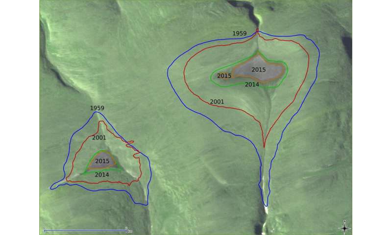
The St. Patrick Bay ice caps on the Hazen Plateau of northeastern Ellesmere Island in Nunavut, Canada, have disappeared, according to NASA satellite imagery. National Snow and Ice Data Center (NSIDC) scientists and colleagues predicted via a 2017 paper in The Cryosphere that the ice caps would melt out completely within the next five years, and recent images from NASA's Advanced Spaceborne Thermal Emission and Reflection Radiometer (ASTER) have confirmed that this prediction was accurate.
M
-
Forum Statistics
8.8k
Total Topics43.5k
Total Posts
-
Latest Posts
-
 Are you ready to level up your geospatial skills? Join our comprehensive training course covering ArcMap, ArcGIS Pro, and ArcOnline—the essential tools for modern spatial analysis and programming! What You’ll Learn: Core functionalities of ArcMap & ArcGIS Pro Cloud-based mapping with ArcGIS Online Automating workflows with Python & ModelBuilder Creating interactive web maps & apps Who Should Enroll? GIS beginners & professionals Urban planners, environmental scientists, & data analysts Developers looking to integrate spatial programming Why Choose This Course? Hands-on projects & real-world applications Expert-led sessions & flexible learning Limited slots available! Click here to register. Let’s shape the future of spatial data together!
 -
GPS is an incredible piece of modern technology. Not only does it allow for locating objects precisely anywhere on the planet, but it also enables the turn-by-turn directions we take for granted these days — all without needing anything more than a radio receiver and some software to decode the signals constantly being sent down from space. [Chris] took that last bit bit as somewhat of a challenge and set off to write a software-defined GPS receiver from the ground up. As GPS started as a military technology, the level of precision needed for things like turn-by-turn navigation wasn’t always available to civilians. The “coarse” positioning is only capable of accuracy within a few hundred meters, so this legacy capability is the first thing that [Chris] tackles here. It is pretty fast, though, with the system able to resolve a location in 24 seconds from cold start and then displaying its information in a browser window. Everything in this build is done in Python as well, meaning that it’s a great starting point for investigating how GPS works and for building other projects from there. The other thing that makes this project accessible is that the only other hardware needed besides a computer that runs Python is an RTL-SDR dongle. These inexpensive TV dongles ushered in a software-defined radio revolution about a decade ago when it was found that they could receive a wide array of radio signals beyond just TV. source: Hackaday and GitHub - chrisdoble/gps-receiver
-
-

-
-
Latest Topics
-
-
Recent Achievements


