- 0 replies
- 1,129 views
- Add Reply
- 5 replies
- 1,660 views
- Add Reply
- 0 replies
- 1,060 views
- Add Reply
- 3 replies
- 1,617 views
- Add Reply
- 1 reply
- 1,310 views
- Add Reply
ArcGIS API and Viewer for Flex 2.5 Available

By EmperoR,


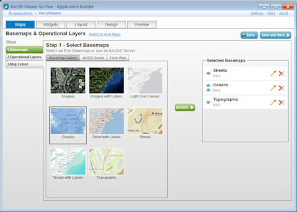
The ArcGIS API for Flex enables you to build dynamic rich Internet applications (RIAs) for ArcGIS Server. The new 2.5 release includes support for WMTS layers, enhanced support for KML, and an improved editing user experience. It also supports cloud-based services hosted on ArcGIS Online (available for those who are beta testing the 10.1 subscription program for ArcGIS Online). Finally, the 2.5 release incorporates bug fixes and enhanced support for ArcGIS.com web maps.
Coinciding with the rel
Convert CA Stateplane to Lon/Lat
By Jozze,
Greetings. I have about 600 data points in NAD 1983 Stateplane California V FIPS 0405 (feet) and I'd like to convert them to Lon/Lat (dms).
What would be the best way to achieve this?
TIA,
Jozze
EGNOS Toolkits Enhance GPS Accuracy

By EmperoR,


software Toolkits can help cell-phone and handheld receiver developers enhance location and timing applications with GPS corrrection data from the European Geostationary Navigation Overlay Service (EGNOS) satellite-based augmentation system.
the Toolkit contains free source code for easy integration of EGNOS capabilities into a smartphone, and all the necessary files for the demonstration application, for use as a basis for a new application, as well as core libraries, to integrate enhanced EG
Around Here Wiki for WP7

By rahmansunbeam,


Discover what's around you with a tap. The Around Here Wiki app puts you and all the world encyclopedia Wikipedia on the map: together.
Have you ever walked through an unfamilar city and wondered: "What's that old building over there?" Just pull out the Around Here Wiki, and you'll find out.
"Is there anything interesting around here to look at?" Around Here Wiki can tell you.
Around Here Wiki is clean, simple and no-fuss. No fancy effects or unnecessary information - just the facts. Wa
Envitia Launches MapLink 7.0

By EmperoR,
Envitia is launching the next generation of MapLink Pro and introducing the most powerful and flexible version of the tool kit to date.
With the release of MapLink Pro 7.0 Envitia delivers on its commitment to provide continued enhancements to the Core SDK and Modules. MapLink Pro 7.0 pushes the envelope of visualisation performance and continues to increase the usability and effectiveness of mapping applications.
Featuring over 400 enhancements to both the Windows and Linux platforms, MapLi
-
Forum Statistics
8.8k
Total Topics43.5k
Total Posts


