- 0 replies
- 1,828 views
- Add Reply
- 0 replies
- 1,808 views
- Add Reply
- 0 replies
- 3,831 views
- Add Reply
- 0 replies
- 1,419 views
- Add Reply
- 0 replies
- 2,172 views
- Add Reply
NGS releases beta tool for obtaining geodetic information

By Lurker,
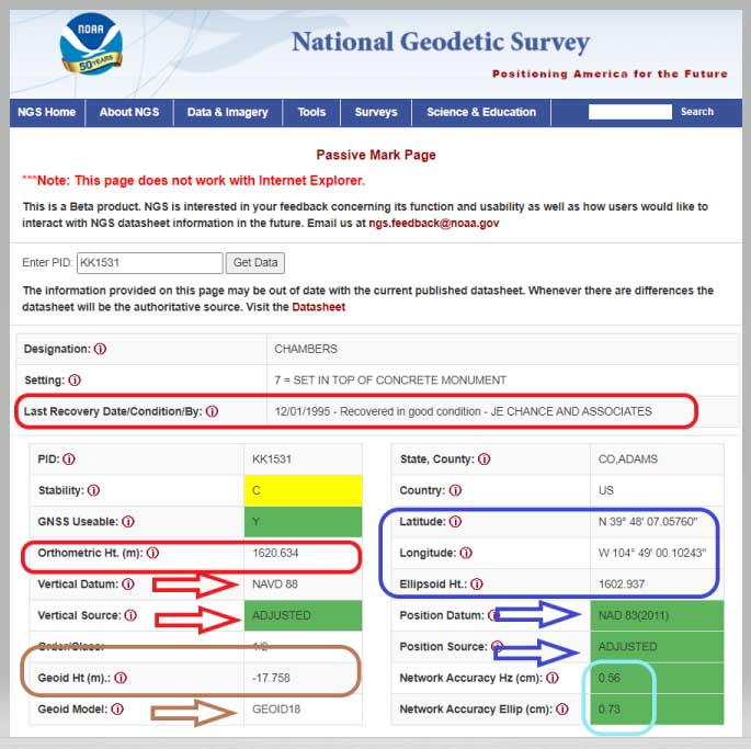
NGS has developed a new beta tool for obtaining geodetic information about a passive mark in their database. This column will highlight some features (available as of Oct. 5, 2020) that may be of interest to GNSS users. It provides all of the information about a station in a more user-friendly format. The box titled “Passive Mark Lookup Tool” is an example of the webtool. The tool provides a lot of information so I have separated the output of the tool into several boxes titled “Passive Mark Loo
NASA Draining the Oceans
By Lurker,
Earth is known as the “Blue Planet” due to the vast bodies of water that cover its surface. With an over 70% of our planet’s surface covered by water, ocean depths offer basins with an abundance of features, such as underwater plateaus, valleys, mountains and trenches. The average depth of the oceans and seas surrounding the continents is around 3,500 meters and parts deeper than 200 meters are called "deep sea".
This visualization reveals Earth’s rich bathymetry, by featuring the ETOPO1 1-
Chrome plugin Earth imagery

By intertronic,
Hello everyone,
a nice plugin for Chrome or Firefox which shows a new satellite imagery (from Google Earth) every time you open a new Tab..
Experience a beautiful image from Google Earth every time you open a new tab.
Earth View displays a beautiful landscape from Google Earth every time you open a new tab.
Chrome :
https://chrome.google.com/webstore/detail/earth-view-from-google-ea/bhloflhklmhfpedakmangadcdofhnnoh?hl=en
Firefox :
https://addons.mozilla.org/en-U
Why your mental map of the world is (probably) wrong

By iron1maiden,
These are some of the most common geographic misconceptions that are both surprising and surprisingly hard to correct.
https://www.nationalgeographic.com/culture/2018/11/all-over-the-map-mental-mapping-misconceptions/
ENVI to Arcmap

By Ghazal,
Hi all,
This is my first time using ENVI and I have applied atmospheric corrections. These are the steps I took:
1- Radiometric correction
2- FLAASH atmospheric correction
3- To eliminate the Negative values and make them between 0 and 1 in data values, I used this formula: (B1 le 0)*0+(B1 ge 10000)*1+(B1 gt 0 and B1 lt 10000)*float (b1)/10000
When I export the corrected later to TIFF, it will be in a 3 band composite but I need single bands to be exported as TIFF so I
-
Forum Statistics
8.8k
Total Topics43.5k
Total Posts
-
Latest Posts
-
 Are you ready to level up your geospatial skills? Join our comprehensive training course covering ArcMap, ArcGIS Pro, and ArcOnline—the essential tools for modern spatial analysis and programming! What You’ll Learn: Core functionalities of ArcMap & ArcGIS Pro Cloud-based mapping with ArcGIS Online Automating workflows with Python & ModelBuilder Creating interactive web maps & apps Who Should Enroll? GIS beginners & professionals Urban planners, environmental scientists, & data analysts Developers looking to integrate spatial programming Why Choose This Course? Hands-on projects & real-world applications Expert-led sessions & flexible learning Limited slots available! Click here to register. Let’s shape the future of spatial data together!
 -
GPS is an incredible piece of modern technology. Not only does it allow for locating objects precisely anywhere on the planet, but it also enables the turn-by-turn directions we take for granted these days — all without needing anything more than a radio receiver and some software to decode the signals constantly being sent down from space. [Chris] took that last bit bit as somewhat of a challenge and set off to write a software-defined GPS receiver from the ground up. As GPS started as a military technology, the level of precision needed for things like turn-by-turn navigation wasn’t always available to civilians. The “coarse” positioning is only capable of accuracy within a few hundred meters, so this legacy capability is the first thing that [Chris] tackles here. It is pretty fast, though, with the system able to resolve a location in 24 seconds from cold start and then displaying its information in a browser window. Everything in this build is done in Python as well, meaning that it’s a great starting point for investigating how GPS works and for building other projects from there. The other thing that makes this project accessible is that the only other hardware needed besides a computer that runs Python is an RTL-SDR dongle. These inexpensive TV dongles ushered in a software-defined radio revolution about a decade ago when it was found that they could receive a wide array of radio signals beyond just TV. source: Hackaday and GitHub - chrisdoble/gps-receiver
-
-

-
-
Latest Topics
-
-
Recent Achievements


