- 0 replies
- 923 views
- Add Reply
- 0 replies
- 1,169 views
- Add Reply
- 0 replies
- 1,125 views
- Add Reply
- 3 replies
- 2,663 views
- Add Reply
- 1 reply
- 4,221 views
- Add Reply
OnYourMap and Blom announce partnership

By Lurker,
OnYourMap and Blom announce partnership and the release of a common high performance mapping platform
OnYourMap and Blom now offer a comprehensive location based platform with services and high quality content for mapping, routing, geocoding and innovative search. This no-compromise platform enables web and mobile portals to boost their presence and revenues while positioning their valuable brand at the forefront and preserving their customers and content.
OnYourMap exclusive internet an
MapMart Cloud Rolls onto the GIS Scene

By Lurker,
MapMart has long been the one-stop shop for traditional geospatial data and imagery acquisition and will remain so. The MapMart Cloud will complement MapMart by offering the same high quality and highly accurate data for consumption via high speed data stream. MapMart Cloud offers hundreds of web services of data sets including Bing Maps from OnTerra Systems, LLC.
MapMart offers a wide variety of U.S. and International geospatial data sets with additional data products coming online daily t
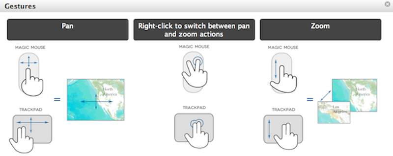
Enhanced map navigation for Mac OS X using the ArcGIS API for JavaScript

By Lurker,


With the release of OS 10.6 Snow Leopard and Lion OS, the Mac Magic Trackpad and Magic Mouse allow you to interact with the system using touch gestures like tap, scroll and swipe. While not all gestures are passed on as native browser events, some gestures emit traditional browser scroll events that enable intuitive and powerful map exploration.
you must have a Mac with OS X 10.6
Wanna study GIS? Click here!

By rahmansunbeam,
Are you planning to study GIS or Remote Sensing? Do you want to be a GIS expert and earn a luck? Here is a huge list of universities and programs from where you can choose what is best for you. Give it a try, maybe the next Goodchild could be you.
US on-campus masters programs
Arizona State University - Masters of Advanced Study in Geographic Information Systems (MAS-GIS)
[hide]
- http://geography.asu.edu/mas-gis
[/hide]
Ball State - Master of Science in Geography, GI Processing Emph
Makai Voyager

By crai0cata,
Sitemap Makai Voyager Explore your scientific world Makai Voyager™ is an advanced 3D/4D visualization software that allows you to view and analyze geospatial data anywhere on earth, including: terrain imagery, elevation, LIDAR, volume and flow data from the ocean and atmosphere, and more.
Beyond traditional desktop GIS software, Makai Voyager includes rich support for time-varying and complex 3D geospatial data. Voyager was developed specifically to visualize and analyze large environmental
-
Forum Statistics
8.8k
Total Topics43.5k
Total Posts


