- 3 replies
- 5,205 views
- Add Reply
- 1 reply
- 1,235 views
- Add Reply
- 3 replies
- 3,432 views
- Add Reply
- 0 replies
- 1,431 views
- Add Reply
- 0 replies
- 2,478 views
- Add Reply
Convert CRS from ESRI:102673 to EPSG:4326

By Zach,
Hi readers,
I have a dataset of ~60,000,000 rows of lidar point data. All spatial reference points are projected using ESRI:102673 (full WKT here: https://epsg.io/102673). I need to convert this to latitude and longitude, EPSG:4326, so that I can overlay other layers and have them match up in the same spacial reference. I am using Python, so any transformation I can do using numpy or pandas will work, or any other free software that gets the job done would be great.
This tool (https://
Field calculation ?

By adamekcerv,
Hi, I have two layers of polygons (gaps in the city) with unique IDs and smaller "lots". These gaps are dissolved from these smaller "lots" polygons (in some cases one lot is equal to one gap). These smaller polygons have the same ID (all ID1 lots - creates one ID1 gap). I have three types of these smaller lots polygons, let's say a, b, c. How to calculate the percentage share (or spatial share ha) of these individual (a,b,c) types of lots in the gap ? Ex: ID1 gap: 30% - type a 50% - type b 20
Add Feature Point by Coordinate (Long,Lat) in QGIS From Postgis Layer

By Reyalino,
Basically, I want to add a feature point by a coordinate in QGIS where the feature itself is loaded from Postgres database. I know there is a plugin called LatLon Tools which provides the tool but sadly it cannot be done when the layer is loaded from Postgres database. anyone knows how to do it?
Emlid launches Reach RS2 multi-band RTK receiver

By Lurker,
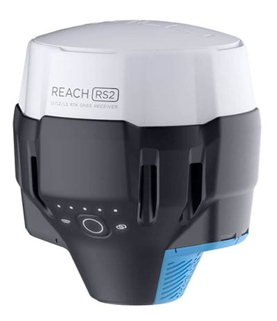
Emlid has debuted the Reach RS2, a fully-featured multi-band RTK receiver. All of its features are available out of the box, along with a survey app for iOS and Android.
The Reach RS2 tracks L1/L2 bands on GPS, GLONASS and BeiDou, and L1/L5 on Galileo, and acquires a fixed solution in seconds. It achieves centimeter-level precision for surveying, mapping and navigation and maintains robust performance even in challenging conditions. Centimeter accuracy can be achieved on distances up to 60
Mapping Carbon Dioxide Emissions from Soil Respiration
By Lurker,

Until recently, there have been no clear assessment of how much CO2 and the role that soils contribute in emissions relative to other greenhouse gases. Now a global scale map using statistical models and satellite imagery, along with other work by scientists, is beginning to indicate how much land use and soil change can affect our planet’s climate.
In a recent study, a series of machine learning models using multiple nonlinear regression (MNLR), random forest regression (RFR), support ve
-
Forum Statistics
8.8k
Total Topics43.5k
Total Posts
-
Latest Posts
-
 Are you ready to level up your geospatial skills? Join our comprehensive training course covering ArcMap, ArcGIS Pro, and ArcOnline—the essential tools for modern spatial analysis and programming! What You’ll Learn: Core functionalities of ArcMap & ArcGIS Pro Cloud-based mapping with ArcGIS Online Automating workflows with Python & ModelBuilder Creating interactive web maps & apps Who Should Enroll? GIS beginners & professionals Urban planners, environmental scientists, & data analysts Developers looking to integrate spatial programming Why Choose This Course? Hands-on projects & real-world applications Expert-led sessions & flexible learning Limited slots available! Click here to register. Let’s shape the future of spatial data together!
 -
GPS is an incredible piece of modern technology. Not only does it allow for locating objects precisely anywhere on the planet, but it also enables the turn-by-turn directions we take for granted these days — all without needing anything more than a radio receiver and some software to decode the signals constantly being sent down from space. [Chris] took that last bit bit as somewhat of a challenge and set off to write a software-defined GPS receiver from the ground up. As GPS started as a military technology, the level of precision needed for things like turn-by-turn navigation wasn’t always available to civilians. The “coarse” positioning is only capable of accuracy within a few hundred meters, so this legacy capability is the first thing that [Chris] tackles here. It is pretty fast, though, with the system able to resolve a location in 24 seconds from cold start and then displaying its information in a browser window. Everything in this build is done in Python as well, meaning that it’s a great starting point for investigating how GPS works and for building other projects from there. The other thing that makes this project accessible is that the only other hardware needed besides a computer that runs Python is an RTL-SDR dongle. These inexpensive TV dongles ushered in a software-defined radio revolution about a decade ago when it was found that they could receive a wide array of radio signals beyond just TV. source: Hackaday and GitHub - chrisdoble/gps-receiver
-
-

-
-
Latest Topics
-
-
Recent Achievements


