- 0 replies
- 1,121 views
- Add Reply
- 0 replies
- 1,139 views
- Add Reply
- 0 replies
- 889 views
- Add Reply
- 0 replies
- 1,952 views
- Add Reply
- 0 replies
- 2,788 views
- Add Reply
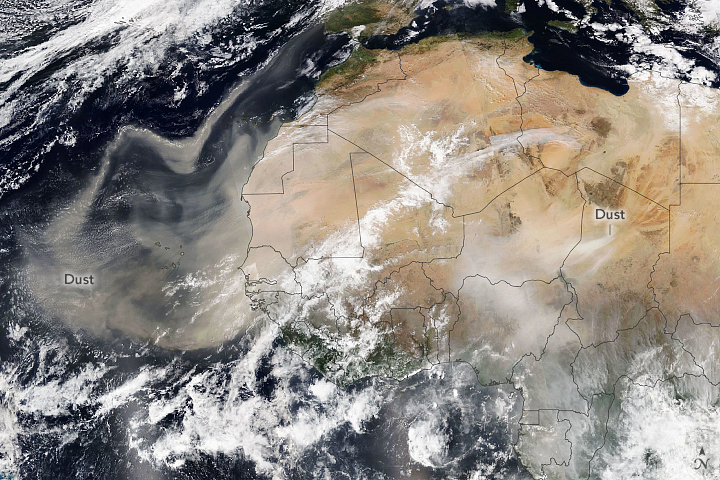
Saharan Dust Heading for Europe

By Lurker,
February 18, 2021
Each year more than 180 million tons of dust blow out from North Africa, lofted out of the Sahara Desert by strong seasonal winds. Perhaps most familiar are the huge, showy plumes that advance across the tropical Atlantic Ocean toward the Americas. But the dust goes elsewhere, too—settling back down in other parts of Africa or drifting north toward Europe.
A dramatic display of airborne dust particles (above) was observed on February 18, 2021, by the Visible In
Soil biodiversity in danger: why it is crucial to protect Soil
By Lurker,
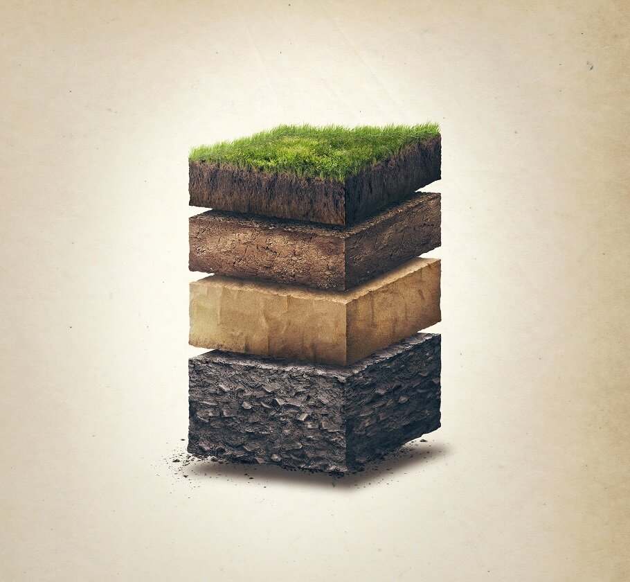
From earthworms to nematodes, from mites to insect larvae, and fungi to bacteria, there are more than 7,000 types of species in our soils. According to The German Center for Integrative Biodiversity, you can find up to 1.5 kilograms of organisms living under a single square meter.
These hidden cities full of thousands of creatures, known as soil organisms, are crucial to creating nutrients from dead plants and animals to keep our soil healthy and grow new plant life. Without healthy n
Mount Etna spews smoke and ash in spectacular new eruption
By Lurker,
Etna produced a very spectacular lava-fountaining eruptive episode, known as paroxysm.
Starting from around 5 p.m. local time in the afternoon, the strombolian activity, which had been going on for the past weeks from the New SE crater intensified significantly. Shortly after, a lava overflow was observed from the eastern side of the South East crater. At 16:05 UTC (5:05 p.m. local time), a part of the eastern flank of the cone collapsed into a pyroclastic flow that traveled down the western wa
Google Maps update brings split screen mode for Street View
By Lurker,

Google Maps for Android is one of the most actively developed Google apps, with new features and improvements routinely being added to the navigation app. In the last two months alone, the app has gained quite a few functionalities, including a new community feed, a Go tab for accessing frequently visited places, messaging for verified businesses, a new driving mode, and food delivery alerts. The app will also soon start showing COVID-19 vaccine locations in the US. Now the Google Maps on Androi
Decoding NOAA Satellite Images Data in Python
By Lurker,
You’d be forgiven for thinking that receiving data transmissions from orbiting satellites requires a complex array of hardware and software, because for a long time it did. These days we have the benefit of cheap software defined radios (SDRs) that let our computers easily tune into arbitrary frequencies. But what about the software side of things? As [Dmitrii Eliuseev] shows, decoding the data satellites are beaming down to Earth is probably a lot easier than you might think.
Well, at leas
-
Forum Statistics
8.8k
Total Topics43.5k
Total Posts
-
Latest Posts
-
 Are you ready to level up your geospatial skills? Join our comprehensive training course covering ArcMap, ArcGIS Pro, and ArcOnline—the essential tools for modern spatial analysis and programming! What You’ll Learn: Core functionalities of ArcMap & ArcGIS Pro Cloud-based mapping with ArcGIS Online Automating workflows with Python & ModelBuilder Creating interactive web maps & apps Who Should Enroll? GIS beginners & professionals Urban planners, environmental scientists, & data analysts Developers looking to integrate spatial programming Why Choose This Course? Hands-on projects & real-world applications Expert-led sessions & flexible learning Limited slots available! Click here to register. Let’s shape the future of spatial data together!
 -
GPS is an incredible piece of modern technology. Not only does it allow for locating objects precisely anywhere on the planet, but it also enables the turn-by-turn directions we take for granted these days — all without needing anything more than a radio receiver and some software to decode the signals constantly being sent down from space. [Chris] took that last bit bit as somewhat of a challenge and set off to write a software-defined GPS receiver from the ground up. As GPS started as a military technology, the level of precision needed for things like turn-by-turn navigation wasn’t always available to civilians. The “coarse” positioning is only capable of accuracy within a few hundred meters, so this legacy capability is the first thing that [Chris] tackles here. It is pretty fast, though, with the system able to resolve a location in 24 seconds from cold start and then displaying its information in a browser window. Everything in this build is done in Python as well, meaning that it’s a great starting point for investigating how GPS works and for building other projects from there. The other thing that makes this project accessible is that the only other hardware needed besides a computer that runs Python is an RTL-SDR dongle. These inexpensive TV dongles ushered in a software-defined radio revolution about a decade ago when it was found that they could receive a wide array of radio signals beyond just TV. source: Hackaday and GitHub - chrisdoble/gps-receiver
-
-

-
-
Latest Topics
-
-
Recent Achievements


