- 0 replies
- 972 views
- Add Reply
- 0 replies
- 1,097 views
- Add Reply
- 0 replies
- 2,996 views
- Add Reply
- 0 replies
- 795 views
- Add Reply
- 0 replies
- 2,909 views
- Add Reply
Algorithm to capture drizzle-turbulence interactions could improve predictions of future climate conditions

By Lurker,
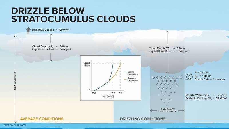
From space, large decks of closely spaced stratocumulus clouds appear like bright cotton balls hovering over the ocean. They cover vast areas—literally thousands of miles of the subtropical oceans—and linger for weeks to months.
Because these marine clouds reflect more solar radiation than the surface of the ocean, cooling the Earth's surface, the lifetime of stratocumulus clouds is an important component of the Earth's radiation balance. It is necessary, then, to accurately represent cloud
Sea-level rise in 20th century was fastest in 2,000 years along much of East Coast
By Lurker,
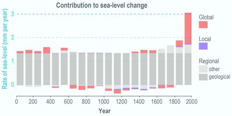
The rate of sea-level rise in the 20th century along much of the U.S. Atlantic coast was the fastest in 2,000 years, and southern New Jersey had the fastest rates, according to a Rutgers-led study.
The global rise in sea-level from melting ice and warming oceans from 1900 to 2000 led to a rate that's more than twice the average for the years 0 to 1800—the most significant change, according to the study in the journal Nature Communications.
The study for the first time looked at the phe
Drill down on map

By Mujda,
Hi, i'm looking for sample of script with Arcpy. For example, i have three hierarchy levels are country, state and district. These fields are geographic fields and I am able to plot them on three separate maps.
The requirement is to create a top-down analysis such that when the user clicks on the country, the top-down analysis should take the user to the states and display all the states. Then when the user clicks on a state, the drilldown should bring the user to see the districts and show
High end of climate sensitivity in new climate models seen as less plausible
By Lurker,

A recent analysis of the latest generation of climate models — known as a CMIP6 — provides a cautionary tale on interpreting climate simulations as scientists develop more sensitive and sophisticated projections of how the Earth will respond to increasing levels of carbon dioxide in the atmosphere.
Researchers at Princeton University and the University of Miami reported that newer models with a high “climate sensitivity” — meaning they predict much greater global warming from the same level
PSLV-C51/Amazonia-1 mission successful, Isro places 19 satellites in orbits
By Lurker,
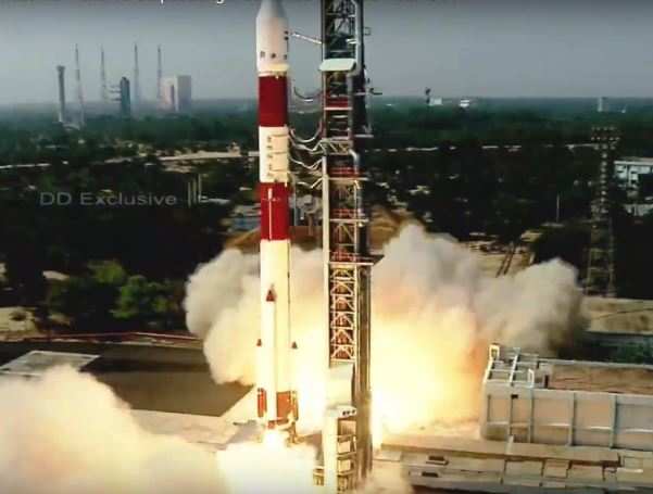
The Indian Space Research Organisation opened its space calendar 2021 with the successful launch of PSLV-C51 carrying Amazonia-1 and 18 other satellites on Sunday.
PSLV-C51 carrying Amazonia-1, an optical earth observation satellite from Brazil, and 18 other satellites lifted off from the first launch pad at Satish Dhawan Space Centre in Sriharikota at 10.24am.
Around 17 minutes after lift-off and one minute after the PS4 engine cut-off, PSLV placed its primary payload -- 637kg weighing Amazon
-
Forum Statistics
8.8k
Total Topics43.5k
Total Posts
-
Latest Posts
-
 Are you ready to level up your geospatial skills? Join our comprehensive training course covering ArcMap, ArcGIS Pro, and ArcOnline—the essential tools for modern spatial analysis and programming! What You’ll Learn: Core functionalities of ArcMap & ArcGIS Pro Cloud-based mapping with ArcGIS Online Automating workflows with Python & ModelBuilder Creating interactive web maps & apps Who Should Enroll? GIS beginners & professionals Urban planners, environmental scientists, & data analysts Developers looking to integrate spatial programming Why Choose This Course? Hands-on projects & real-world applications Expert-led sessions & flexible learning Limited slots available! Click here to register. Let’s shape the future of spatial data together!
 -
GPS is an incredible piece of modern technology. Not only does it allow for locating objects precisely anywhere on the planet, but it also enables the turn-by-turn directions we take for granted these days — all without needing anything more than a radio receiver and some software to decode the signals constantly being sent down from space. [Chris] took that last bit bit as somewhat of a challenge and set off to write a software-defined GPS receiver from the ground up. As GPS started as a military technology, the level of precision needed for things like turn-by-turn navigation wasn’t always available to civilians. The “coarse” positioning is only capable of accuracy within a few hundred meters, so this legacy capability is the first thing that [Chris] tackles here. It is pretty fast, though, with the system able to resolve a location in 24 seconds from cold start and then displaying its information in a browser window. Everything in this build is done in Python as well, meaning that it’s a great starting point for investigating how GPS works and for building other projects from there. The other thing that makes this project accessible is that the only other hardware needed besides a computer that runs Python is an RTL-SDR dongle. These inexpensive TV dongles ushered in a software-defined radio revolution about a decade ago when it was found that they could receive a wide array of radio signals beyond just TV. source: Hackaday and GitHub - chrisdoble/gps-receiver
-
-

-
-
Latest Topics
-
-
Recent Achievements


