- 1 reply
- 4,823 views
- Add Reply
- 0 replies
- 889 views
- Add Reply
- 0 replies
- 1,649 views
- Add Reply
- 0 replies
- 923 views
- Add Reply
- 0 replies
- 1,541 views
- Add Reply
2020 Global Land Use Data

By Lurker,

A global land cover GeoTIFF was recently released by Impact Observatory (IO) and Esri. To create this geospatial layer, hundreds of thousands of satellite photos were classified into ten unique land use/land cover (LULC) classes using a deep learning model in partnership with Microsoft AI for Earth.
Sentinel-2 imagery was used to divide the world into ten categories of land use cover:
Water (areas that are predominately water such as rivers ponds, lakes, and ocean)
Trees (clusters
The 27.5-million-year cycle of geological activity
By Lurker,
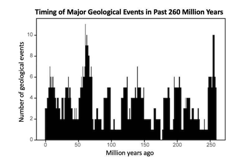
Geologic activity on Earth appears to follow a 27.5-million-year cycle, giving the planet a 'pulse,' according to a new study published in the journal Geoscience Frontiers.
"Many geologists believe that geological events are random over time. But our study provides statistical evidence for a common cycle, suggesting that these geologic events are correlated and not random," said Michael Rampino, a geologist and professor in New York University's Department of Biology, as well as the study's
A satellite’s view of a deadly 2019 eruption could improve volcano monitoring
By Lurker,

On December 9, 2019, a cloud of steam and volcanic gases blasted out of New Zealand’s Whakaari, or White Island, volcano. Relative to eruptions at other volcanoes, the explosion was small. But it claimed the lives of 22 people and injured another 25, many of whom suffered severe burns.
Now, using high-resolution satellite data and computer algorithms, scientists have revealed how gases released by the volcano subtly changed before, during and after the 2019 eruption. Observing such sm
A magnetic field reversal 42,000 years ago may have contributed to mass extinctions
By Lurker,
A flip-flop of Earth’s magnetic poles between 42,000 and 41,000 years ago briefly but dramatically shrank the magnetic field’s strength — and may have triggered a cascade of environmental crises on Earth, a new study suggests.
With the help of new, precise carbon dating obtained from ancient tree fossils, the researchers correlated shifts in climate patterns, large mammal extinctions and even changes in human behavior just before and during the Laschamps excursion, a brief reversal of the m
Javad GNSS launches TRIUMPH-3 receiver
By Lurker,

Javad GNSS has launched the TRIUMPH-3 receiver for surveyors and geodesists. It is capable of efficient tracking even in difficult conditions. It can track all current signals and is ready for any future satellites.
TRIUMPH-3 is designed to operate as a base together with TRIUMPH-LS and TRIUMPH-LS Plus to efficiently accomplish any geodetic job. Its real-time kinematic (RTK) system communicates via integrated UHF, 4G/LTE, Wi-Fi and Bluetooth channels, and eliminates the need to subscribe to
-
Forum Statistics
8.8k
Total Topics43.5k
Total Posts
-
Latest Posts
-
 Are you ready to level up your geospatial skills? Join our comprehensive training course covering ArcMap, ArcGIS Pro, and ArcOnline—the essential tools for modern spatial analysis and programming! What You’ll Learn: Core functionalities of ArcMap & ArcGIS Pro Cloud-based mapping with ArcGIS Online Automating workflows with Python & ModelBuilder Creating interactive web maps & apps Who Should Enroll? GIS beginners & professionals Urban planners, environmental scientists, & data analysts Developers looking to integrate spatial programming Why Choose This Course? Hands-on projects & real-world applications Expert-led sessions & flexible learning Limited slots available! Click here to register. Let’s shape the future of spatial data together!
 -
GPS is an incredible piece of modern technology. Not only does it allow for locating objects precisely anywhere on the planet, but it also enables the turn-by-turn directions we take for granted these days — all without needing anything more than a radio receiver and some software to decode the signals constantly being sent down from space. [Chris] took that last bit bit as somewhat of a challenge and set off to write a software-defined GPS receiver from the ground up. As GPS started as a military technology, the level of precision needed for things like turn-by-turn navigation wasn’t always available to civilians. The “coarse” positioning is only capable of accuracy within a few hundred meters, so this legacy capability is the first thing that [Chris] tackles here. It is pretty fast, though, with the system able to resolve a location in 24 seconds from cold start and then displaying its information in a browser window. Everything in this build is done in Python as well, meaning that it’s a great starting point for investigating how GPS works and for building other projects from there. The other thing that makes this project accessible is that the only other hardware needed besides a computer that runs Python is an RTL-SDR dongle. These inexpensive TV dongles ushered in a software-defined radio revolution about a decade ago when it was found that they could receive a wide array of radio signals beyond just TV. source: Hackaday and GitHub - chrisdoble/gps-receiver
-
-

-
-
Latest Topics
-
-
Recent Achievements


