- 0 replies
- 1,334 views
- Add Reply
- 0 replies
- 1,261 views
- Add Reply
- 0 replies
- 1,551 views
- Add Reply
- 1 reply
- 2,053 views
- Add Reply
- 0 replies
- 1,151 views
- Add Reply
Rainfall becomes increasingly variable as climate warms

By Lurker,
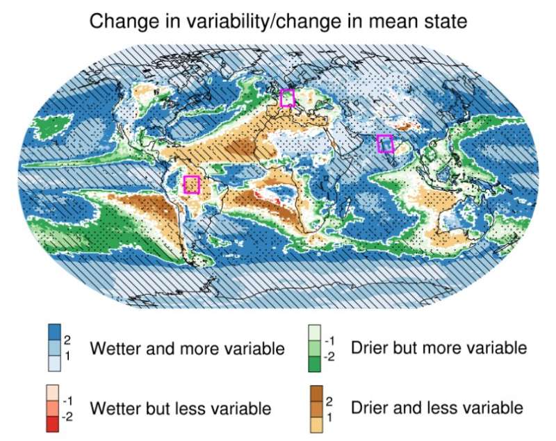
Classification of precipitation change regimes based on changes in the precipitation mean state and variability. Shading indicates the ratio of change in precipitation variability and mean precipitation.
Climate models predict that rainfall variability over wet regions globally will be greatly enhanced by global warming, causing wide swings between dry and wet conditions, according to a joint study by the Institute of Atmospheric Physics (IAP) of the Chinese Academy of Science
Earth's interior is swallowing up more carbon than thought
By Lurker,

Scientists from Cambridge University and NTU Singapore have found that slow-motion collisions of tectonic plates drag more carbon into Earth's interior than previously thought.
They found that the carbon drawn into Earth's interior at subduction zones—where tectonic plates collide and dive into Earth's interior—tends to stay locked away at depth, rather than resurfacing in the form of volcanic emissions.
Their findings, published in Nature Communications, suggest that only about a thir
Honeywell debuts MEMS sensor to help small sats navigate
By Lurker,

Honeywell has unveiled a new rate sensor to help small satellites navigate increasingly crowded orbits above the Earth’s surface. The new micro-electro-mechanical system (MEMS)-based product provides low cost and power consumption in a smaller size than previous Honeywell offerings, while maintaining high performance levels. It is suitable for customers building smaller and lower-cost satellites, according to Honeywell.
Honeywell’s HG4934 space rate sensor is roughly the same size and weigh
Esri UC 2021: What's new and what's not

By rahmansunbeam,

The all-virtual Esri User Conference 2021 just dropped the curtain after a four-day event. Here's whats new.
Everything new explained by Jack Dangermond.
ArcGIS Image is a software for remote sensing over cloud.
ArcGIS Velocity gets real-time data visualization maps.
ArcGIS Enterprise installation using Kubernetes.
More experiments with field survey. 😑
More integrated BIM for ArcGIS.
Maps SDK
UN confirms 18.3C record on temperature in Antarctica
By Lurker,
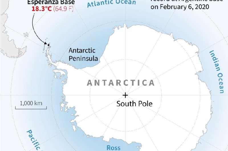
The United Nations on Thursday recognised a new record high temperature for the Antarctic continent, confirming a reading of 18.3 degrees Celsius (64.9 degrees Fahrenheit) made last year.
The record heat was reached at Argentina's Esperanza research station on the Antarctic Peninsula on February 6, 2020, the UN's World Meteorological Organization said.
"Verification of this maximum temperature record is important because it helps us to build up a picture of the weather and climate in o
-
Forum Statistics
8.8k
Total Topics43.5k
Total Posts
-
Latest Posts
-
 Are you ready to level up your geospatial skills? Join our comprehensive training course covering ArcMap, ArcGIS Pro, and ArcOnline—the essential tools for modern spatial analysis and programming! What You’ll Learn: Core functionalities of ArcMap & ArcGIS Pro Cloud-based mapping with ArcGIS Online Automating workflows with Python & ModelBuilder Creating interactive web maps & apps Who Should Enroll? GIS beginners & professionals Urban planners, environmental scientists, & data analysts Developers looking to integrate spatial programming Why Choose This Course? Hands-on projects & real-world applications Expert-led sessions & flexible learning Limited slots available! Click here to register. Let’s shape the future of spatial data together!
 -
GPS is an incredible piece of modern technology. Not only does it allow for locating objects precisely anywhere on the planet, but it also enables the turn-by-turn directions we take for granted these days — all without needing anything more than a radio receiver and some software to decode the signals constantly being sent down from space. [Chris] took that last bit bit as somewhat of a challenge and set off to write a software-defined GPS receiver from the ground up. As GPS started as a military technology, the level of precision needed for things like turn-by-turn navigation wasn’t always available to civilians. The “coarse” positioning is only capable of accuracy within a few hundred meters, so this legacy capability is the first thing that [Chris] tackles here. It is pretty fast, though, with the system able to resolve a location in 24 seconds from cold start and then displaying its information in a browser window. Everything in this build is done in Python as well, meaning that it’s a great starting point for investigating how GPS works and for building other projects from there. The other thing that makes this project accessible is that the only other hardware needed besides a computer that runs Python is an RTL-SDR dongle. These inexpensive TV dongles ushered in a software-defined radio revolution about a decade ago when it was found that they could receive a wide array of radio signals beyond just TV. source: Hackaday and GitHub - chrisdoble/gps-receiver
-
-

-
-
Latest Topics
-
-
Recent Achievements


