- 4 replies
- 3,129 views
- Add Reply
- 0 replies
- 1,715 views
- Add Reply
- 0 replies
- 1,076 views
- Add Reply
- 1 reply
- 2,607 views
- Add Reply
- 0 replies
- 1,830 views
- Add Reply
Terrain Modification with road networks

By Birdfree,
Hello, I am looking for a solution to merge elevation models with a road network. Basis is a elevation model and shape data of roads. Now I want to merge the roads with the elevation model to get flat roads in the elevation model. Do you know of any software that can do this? I have been searching for a while, but have not found a solution yet. So far I've been using Photoshop's blur to even out the color values a bit and at least get a decent result for large scales. But, the streets are sloped
NTIA's interactive broadband map highlights the digital divide

By Lurker,
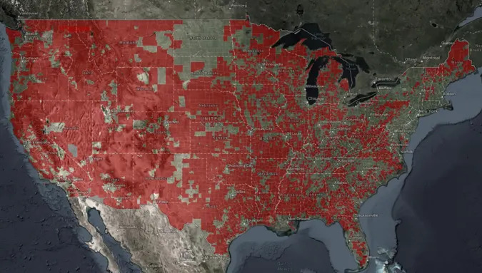
The quality and cost of broadband remain issues for households across the US, and the Biden administration wants to draw attention to that unfortunate reality. The National Telecommunications and Information Administration (NTIA) has published what it says is the first interactive public map detailing the "digital divide" in broadband access. You'll not only see areas where broadband speeds fall below official targets (25Mbps down and 3Mbps up), but correlate that with high-poverty areas. You ca
Managing earthquakes triggered by oil production: Scientists demonstrate safer wastewater disposal method
By Lurker,
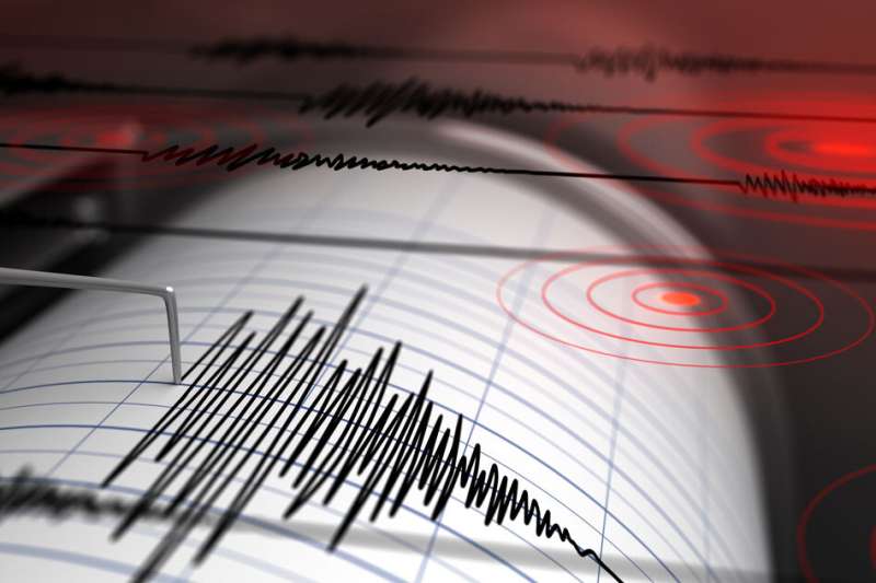
When humans pump large volumes of fluid into the ground, they can set off potentially damaging earthquakes, depending on the underlying geology. This has been the case in certain oil- and gas-producing regions, where wastewater, often mixed with oil, is disposed of by injecting it back into the ground—a process that has triggered sizable seismic events in recent years.
Now MIT researchers, working with an interdisciplinary team of scientists from industry and academia, have developed a meth
Landsat 7 End of Life Plans
By Lurker,

On February 7, 2017, the twentieth and final inclination (Delta-I) maneuver of Landsat 7 took place. (Delta-I maneuvers keep the spacecraft in the correct orbital position to ensure it maintains its 10:00 am ± 15 minutes mean local time (MLT) equatorial crossing.) Landsat 7 reached its peak outermost inclination boundary of 10:14:58 MLT on August 11, 2017.
Landsat 7 is now drifting in its inclination and will fall back to 09:15 am MLT by July 2021. The chart below illustrates the inclinati
Mapping Shows Africa Has Plenty of Groundwater
By Lurker,
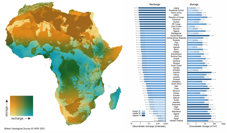
Many of Africa’s agricultural endeavors have long been tied to whims of the weather. When it rains, a country’s gross domestic product might soar. When it doesn’t rain, economies suffer. The reliance has been driven in part by the perception that dry, arid Africa has limited water resources. But a new study, years in the making, shows a different reality.
As one South African scientist recently noted, if all the rainfall stopped today and for the next 100 years in Africa, there would still
-
Forum Statistics
8.8k
Total Topics43.5k
Total Posts
-
Latest Posts
-
 Are you ready to level up your geospatial skills? Join our comprehensive training course covering ArcMap, ArcGIS Pro, and ArcOnline—the essential tools for modern spatial analysis and programming! What You’ll Learn: Core functionalities of ArcMap & ArcGIS Pro Cloud-based mapping with ArcGIS Online Automating workflows with Python & ModelBuilder Creating interactive web maps & apps Who Should Enroll? GIS beginners & professionals Urban planners, environmental scientists, & data analysts Developers looking to integrate spatial programming Why Choose This Course? Hands-on projects & real-world applications Expert-led sessions & flexible learning Limited slots available! Click here to register. Let’s shape the future of spatial data together!
 -
GPS is an incredible piece of modern technology. Not only does it allow for locating objects precisely anywhere on the planet, but it also enables the turn-by-turn directions we take for granted these days — all without needing anything more than a radio receiver and some software to decode the signals constantly being sent down from space. [Chris] took that last bit bit as somewhat of a challenge and set off to write a software-defined GPS receiver from the ground up. As GPS started as a military technology, the level of precision needed for things like turn-by-turn navigation wasn’t always available to civilians. The “coarse” positioning is only capable of accuracy within a few hundred meters, so this legacy capability is the first thing that [Chris] tackles here. It is pretty fast, though, with the system able to resolve a location in 24 seconds from cold start and then displaying its information in a browser window. Everything in this build is done in Python as well, meaning that it’s a great starting point for investigating how GPS works and for building other projects from there. The other thing that makes this project accessible is that the only other hardware needed besides a computer that runs Python is an RTL-SDR dongle. These inexpensive TV dongles ushered in a software-defined radio revolution about a decade ago when it was found that they could receive a wide array of radio signals beyond just TV. source: Hackaday and GitHub - chrisdoble/gps-receiver
-
-

-
-
Latest Topics
-
-
Recent Achievements
-


")


