- 0 replies
- 9,918 views
- Add Reply
- 1 reply
- 5,248 views
- Add Reply
- 0 replies
- 3,458 views
- Add Reply
- 0 replies
- 3,063 views
- Add Reply
- 1 reply
- 7,425 views
- Add Reply
Mountaintop removal worse for endangered species than initially thought

By Lurker,

A new study published today by journal PLOS ONE has revealed that mountaintop removal mining poses a more serious and widespread threat to endangered species and people than was previously understood. The researchers from Defenders of Wildlife's Center for Conservation Innovation (CCI) and conservation technology nonprofit SkyTruth, combine water-quality data with satellite imagery of mountaintop removal mining activity to estimate the full extent of water-quality degradation attributable to the
Calculation of the TSAVI vegetation index

By achraf98,
Hi. I am working on a remote sensing project about land degradation. I want to calculate TSAVI using a Landsat-8 image but I can't find how the a and b (slope and intercept) parameters are calculated. I only know that the variable X=0.08 according to the litterature. Can someone help me?
Kleos commits to build and launch fourth satellite cluster
By Lurker,
Kleos Space S.A (ASX:KSS, Frankfurt:KS1, Kleos or Company), a space-powered Radio Frequency Reconnaissance data-as-a-service (DaaS) company, has signed new contracts with satellite builder Innovative Solutions in Space B.V. (ISISPACE) and global launch services provider Spaceflight Inc to build and manage the launch its fourth satellite cluster of four satellites, the Observer Mission (KSF3) mid-2022.
Kleos Space CEO Andy Bowyer said, “We are rapidly building our constellation, utilising fu
NOAA's surfing drone captured footage inside Hurricane Sam
By Lurker,
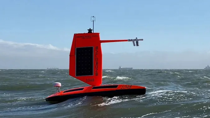
The National Oceanic and Atmospheric Administration has shared what it says are the first images and video captured inside a hurricane by a surface drone. The agency placed the Saildrone Explorer SD 1045 in the path of the category-four Hurricane Sam. The saildrone overcame 50-foot waves and winds at speeds topping 120 miles per hour to capture data from the hurricane and offer a new perspective into such storms.
The device has a special “hurricane wing” to help it survive the intense wind
asking question about geopands

By zolfa,
hello
how can i solve the problem of geopandas installation ?
i can not install geopandas in anaconda
would possible to help me ?
-
Forum Statistics
8.8k
Total Topics43.5k
Total Posts
-
Latest Posts
-
 Are you ready to level up your geospatial skills? Join our comprehensive training course covering ArcMap, ArcGIS Pro, and ArcOnline—the essential tools for modern spatial analysis and programming! What You’ll Learn: Core functionalities of ArcMap & ArcGIS Pro Cloud-based mapping with ArcGIS Online Automating workflows with Python & ModelBuilder Creating interactive web maps & apps Who Should Enroll? GIS beginners & professionals Urban planners, environmental scientists, & data analysts Developers looking to integrate spatial programming Why Choose This Course? Hands-on projects & real-world applications Expert-led sessions & flexible learning Limited slots available! Click here to register. Let’s shape the future of spatial data together!
 -
GPS is an incredible piece of modern technology. Not only does it allow for locating objects precisely anywhere on the planet, but it also enables the turn-by-turn directions we take for granted these days — all without needing anything more than a radio receiver and some software to decode the signals constantly being sent down from space. [Chris] took that last bit bit as somewhat of a challenge and set off to write a software-defined GPS receiver from the ground up. As GPS started as a military technology, the level of precision needed for things like turn-by-turn navigation wasn’t always available to civilians. The “coarse” positioning is only capable of accuracy within a few hundred meters, so this legacy capability is the first thing that [Chris] tackles here. It is pretty fast, though, with the system able to resolve a location in 24 seconds from cold start and then displaying its information in a browser window. Everything in this build is done in Python as well, meaning that it’s a great starting point for investigating how GPS works and for building other projects from there. The other thing that makes this project accessible is that the only other hardware needed besides a computer that runs Python is an RTL-SDR dongle. These inexpensive TV dongles ushered in a software-defined radio revolution about a decade ago when it was found that they could receive a wide array of radio signals beyond just TV. source: Hackaday and GitHub - chrisdoble/gps-receiver
-
-

-
-
Latest Topics
-
-
Recent Achievements


