- 0 replies
- 1,515 views
- Add Reply
- 0 replies
- 1,416 views
- Add Reply
- 0 replies
- 1,161 views
- Add Reply
- 0 replies
- 1,512 views
- Add Reply
- 0 replies
- 4,034 views
- Add Reply
NASA developing drones to monitor potential volcano eruptions

By Lurker,
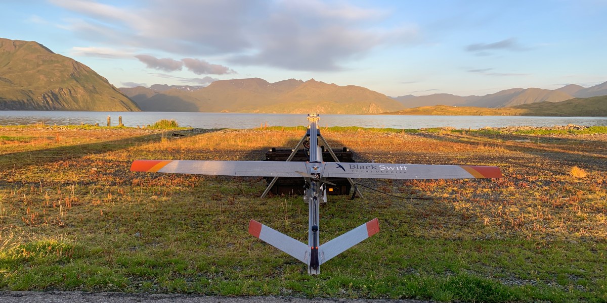
NASA has partnered with other US agencies and a Colorado-based drone manufacturer to create a UAV-based system to observe volcanoes for indications of what otherwise might be unexpected, catastrophic eruptions for local communities.
NASA has long been interested in deploying drones to replace human monitors and small aircraft habitually used for near-range examination of volcano activity and for gathering evidence of approaching eruptions. Tipped off to those by data collected with sensors
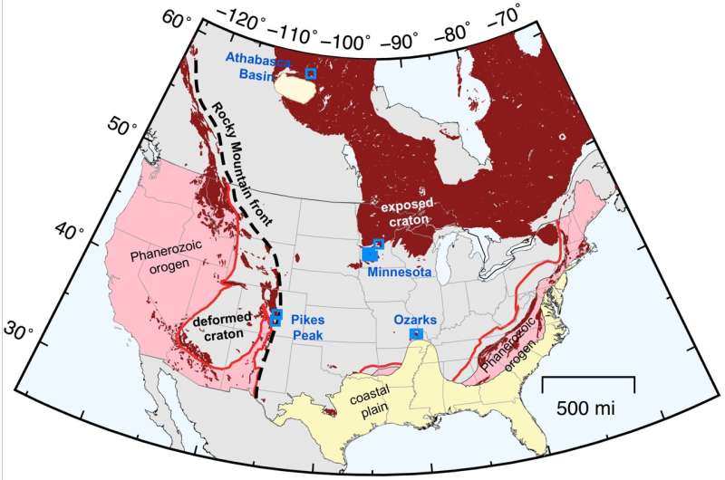
Wild New Paper Suggests Earth's Tectonic Activity Has an Unseen Source
By Lurker,
Earth is far from a solid mass of rock. The outer layer of our planet – known as the lithosphere – is made up of more than 20 tectonic plates; as these gargantuan slates glide about the face of the planet, we get the movement of continents, and interaction at the boundaries, not least of which is the rise and fall of entire mountain ranges and oceanic trenches.
Yet there's some debate over what causes these giant slabs of rock to move around in the first place.
Amongst the many hypothe
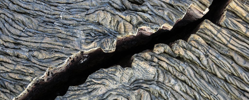
New research strengthens link between glaciers and Earth's 'Great Unconformity'
By Lurker,
New research provides further evidence that rocks representing up to a billion years of geological time were carved away by ancient glaciers during the planet's "Snowball Earth" period, according to a study published in Proceedings of the National Academy of Sciences.
The research presents the latest findings in a debate over what caused the Earth's "Great Unconformity"—a time gap in the geological record associated with the erosion of rock up to 3 miles thick in areas across the globe.
Map the Oceans, To Save Earth’s Climate
By Lurker,
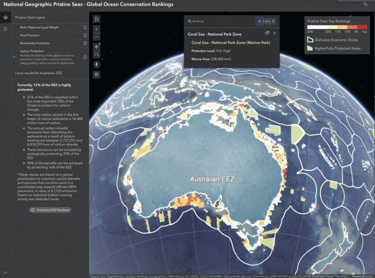
It is worth repeating that scientists know more about Mars, Venus, and the dark side of the moon than they know of Earth’s ocean depths. To date, less than 20 percent of the ocean floor has been mapped—13 percent in just the past four years. But scientists would like to map it all by 2030. It’s an essential undertaking, but it’s going to take dedicated effort, public support, and government funding. Such a project can be accomplished only through dedicated global cooperation.
The payoff sta
Moving Beyond the Geospatial Machine Learning Hype

By ckamusoko,
Land cover classification remains challenging. However, more very high-resolution images are available to create quality reference data. In addition, efforts to improve transparency and accountability in the machine learning model are becoming an important research topic. I have published a book on ‘Data-centric Explainable Machine Learning for Land Cover Classification: A Practical Guide in R.’ The book is for those interested in improving land cover classification using a data-centric explaina
-
Forum Statistics
8.8k
Total Topics43.5k
Total Posts
-
Latest Posts
-
 Are you ready to level up your geospatial skills? Join our comprehensive training course covering ArcMap, ArcGIS Pro, and ArcOnline—the essential tools for modern spatial analysis and programming! What You’ll Learn: Core functionalities of ArcMap & ArcGIS Pro Cloud-based mapping with ArcGIS Online Automating workflows with Python & ModelBuilder Creating interactive web maps & apps Who Should Enroll? GIS beginners & professionals Urban planners, environmental scientists, & data analysts Developers looking to integrate spatial programming Why Choose This Course? Hands-on projects & real-world applications Expert-led sessions & flexible learning Limited slots available! Click here to register. Let’s shape the future of spatial data together!
 -
GPS is an incredible piece of modern technology. Not only does it allow for locating objects precisely anywhere on the planet, but it also enables the turn-by-turn directions we take for granted these days — all without needing anything more than a radio receiver and some software to decode the signals constantly being sent down from space. [Chris] took that last bit bit as somewhat of a challenge and set off to write a software-defined GPS receiver from the ground up. As GPS started as a military technology, the level of precision needed for things like turn-by-turn navigation wasn’t always available to civilians. The “coarse” positioning is only capable of accuracy within a few hundred meters, so this legacy capability is the first thing that [Chris] tackles here. It is pretty fast, though, with the system able to resolve a location in 24 seconds from cold start and then displaying its information in a browser window. Everything in this build is done in Python as well, meaning that it’s a great starting point for investigating how GPS works and for building other projects from there. The other thing that makes this project accessible is that the only other hardware needed besides a computer that runs Python is an RTL-SDR dongle. These inexpensive TV dongles ushered in a software-defined radio revolution about a decade ago when it was found that they could receive a wide array of radio signals beyond just TV. source: Hackaday and GitHub - chrisdoble/gps-receiver
-
-

-
-
Latest Topics
-
-
Recent Achievements


