- 1 reply
- 2,110 views
- Add Reply
- 1 reply
- 5,045 views
- Add Reply
- 1 reply
- 1,884 views
- Add Reply
- 0 replies
- 1,666 views
- Add Reply
- 0 replies
- 1,607 views
- Add Reply
What's New in ArcGIS Pro 3.0

By Lurker,
Highlights
Now that you’re caught up to speed and ready to run the latest release of ArcGIS Pro, here are some of our favorite features that we are excited to bring you.
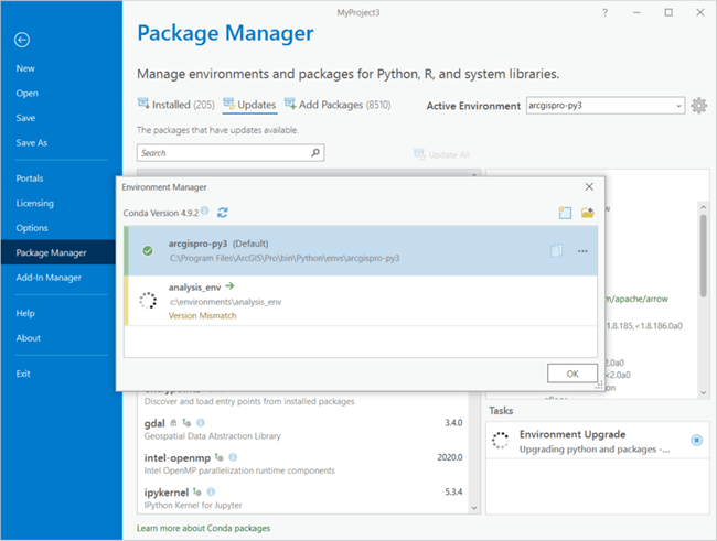
Package Manager
The Package Manager page allows you to manage conda environments for use within ArcGIS Pro. Formerly identified as the Python page, the Package Manager page now supports the upgrade of conda environments you’ve created in previous versions of ArcGIS Pro to the current version, the repair of b
Near-real-time 10m resolution global land cover data has arrived

By rahmansunbeam,
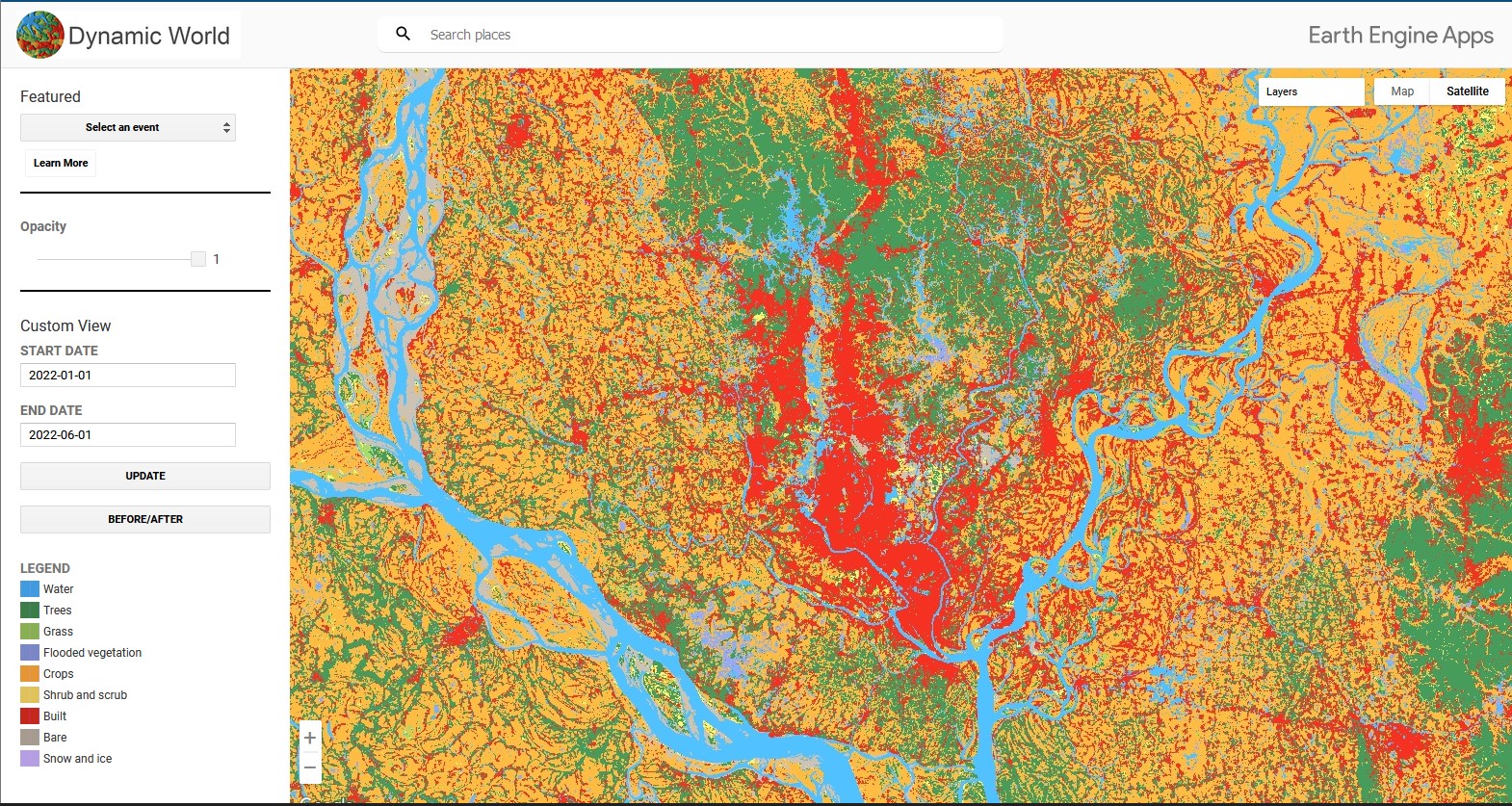
World Resources Institute and Google announced 10m resolution global land cover data called Dynamic World powered by Google Earth Engine and AI Platform. Dynamic World is a 10m near-real-time LULC dataset that includes nine classes and available for the Sentinel-2 L1C collection from 2015 until today.
The incredible James Webb Space Telescope Images will be released next month
By rahmansunbeam,
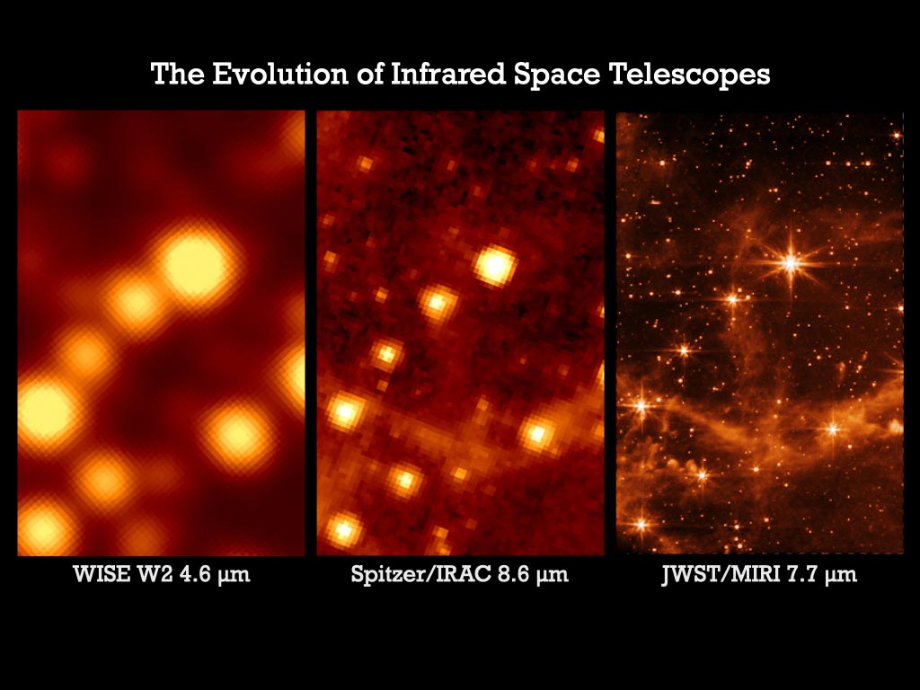
The images above are released by the James Webb Space Telescope (JWST) team aren’t officially ‘first light’ images from the new telescope, but in a way, it feels like they are. These stunning views provide the initial indications of just how powerful JWST will be, and just how much infrared astronomy is about to improve.
The images were released following the completion of the long process to fully focus the telescope’s mirror segments. Engineers are saying JWST’s optical performance is “be
Google Maps “immersive view” is the ultimate graphics mode for Google Maps
By Lurker,

For most uses, Google Maps is a flat, 2D app, and if your device can handle more graphics and a bit more data, you can fire up the Google Earth 3D data set and get 3D buildings. At Google I/O Google has announced a new level that turns the graphics slider way, way up on Google Maps: Immersive View. When exploring an area in Google Maps, the company says Immersive View will make it "feel like you’re right there before you ever set foot inside."
The video for this feature is wild. It basicall
Machine learning and gravity signals could rapidly detect big earthquakes
By Lurker,

Massive earthquakes don’t just move the ground — they make speed-of-light adjustments to Earth’s gravitational field. Now, researchers have trained computers to identify these tiny gravitational signals, demonstrating how the signals can be used to mark the location and size of a strong quake almost instantaneously.
It’s a first step to creating a very early warning system for the planet’s most powerful quakes, scientists report May 11 in Nature.
Such a system could help solve a thorny
-
Forum Statistics
8.8k
Total Topics43.5k
Total Posts
-
Latest Posts
-
 Are you ready to level up your geospatial skills? Join our comprehensive training course covering ArcMap, ArcGIS Pro, and ArcOnline—the essential tools for modern spatial analysis and programming! What You’ll Learn: Core functionalities of ArcMap & ArcGIS Pro Cloud-based mapping with ArcGIS Online Automating workflows with Python & ModelBuilder Creating interactive web maps & apps Who Should Enroll? GIS beginners & professionals Urban planners, environmental scientists, & data analysts Developers looking to integrate spatial programming Why Choose This Course? Hands-on projects & real-world applications Expert-led sessions & flexible learning Limited slots available! Click here to register. Let’s shape the future of spatial data together!
 -
GPS is an incredible piece of modern technology. Not only does it allow for locating objects precisely anywhere on the planet, but it also enables the turn-by-turn directions we take for granted these days — all without needing anything more than a radio receiver and some software to decode the signals constantly being sent down from space. [Chris] took that last bit bit as somewhat of a challenge and set off to write a software-defined GPS receiver from the ground up. As GPS started as a military technology, the level of precision needed for things like turn-by-turn navigation wasn’t always available to civilians. The “coarse” positioning is only capable of accuracy within a few hundred meters, so this legacy capability is the first thing that [Chris] tackles here. It is pretty fast, though, with the system able to resolve a location in 24 seconds from cold start and then displaying its information in a browser window. Everything in this build is done in Python as well, meaning that it’s a great starting point for investigating how GPS works and for building other projects from there. The other thing that makes this project accessible is that the only other hardware needed besides a computer that runs Python is an RTL-SDR dongle. These inexpensive TV dongles ushered in a software-defined radio revolution about a decade ago when it was found that they could receive a wide array of radio signals beyond just TV. source: Hackaday and GitHub - chrisdoble/gps-receiver
-
-

-
-
Latest Topics
-
-
Recent Achievements
-


")


