- 0 replies
- 2,107 views
- Add Reply
- 0 replies
- 3,295 views
- Add Reply
- 0 replies
- 1,446 views
- Add Reply
- 0 replies
- 2,349 views
- Add Reply
- 0 replies
- 2,029 views
- Add Reply
GIS Day Webinar Event

By IRES,
Hello! Hello!
Join us on Wednesday [GIS DAA] for a zoom webinar as we discuss "The Future of GIS: Emerging Technologies and Global Impact in Different Sectors" and "GIS for Sustainable Development."
Our event will feature two distinguished key speakers, senior specialists in the field, who will enlighten us with their insights and expertise.
Save the date and stay tuned for more details on this exciting opportunity to explore the cutting-edge advancements and
Tiny LoRa GPS Node Relies On ESP32

By Lurker,
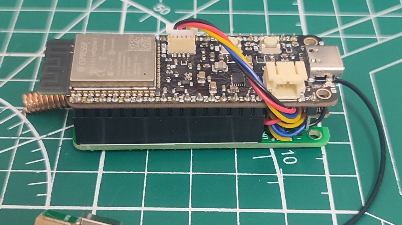
Sometimes you need to create a satellite navigation tracking device that communicates via a low-power mesh network. [Powerfeatherdev] was in just that situation, and they whipped up a particularly compact solution to do the job.
As you might have guessed based on the name of its creator, this build is based around the ESP32-S3 PowerFeather board. The PowerFeather has the benefit of robust power management features, which makes it perfect for a power-sipping project that’s intended to run fo
Single Rotor Drone Spins For 360 Lidar Scanning
By Lurker,
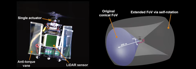
Multiple motors or servos are the norm for drones to achieve controllable flight, but a team from MARS LAB HKU was able to a 360° lidar scanning drone with full control on just a single motor and no additional actuators. Video after the break.
The key to controllable flight is the swashplateless propeller design that we’ve seen a few times, but it always required a second propeller to counteract self-rotation. In this case, the team was able to make that self-rotation work so that they coul
Blue Marble Geographics Releases Global Mapper v26.0 with New Deep Learning Image Analysis in the Global Mapper Insight and Learning Engine (Beta)
By Lurker,
The fall update to Global Mapper includes numerous usability updates, processing improvements, and with Pro, beta access to the Global Mapper Insight and Learning Engine which contains deep learning-based image analysis tools.
Global Mapper is a complete geospatial software solution. The Standard version excels at basic vector, raster, and terrain editing, with Global Mapper Pro expanding the toolset to support drone-collected image processing, point cloud classification and extraction, and
ESA releases new strategy for Earth observation
By Lurker,
Responding to the escalating threats from climate change, biodiversity loss, pollution and extreme weather and the need to take action to address these threats, this forward-looking strategy outlines a bold vision for Earth science through to 2040.
By leveraging advanced satellite-based monitoring of our planet, ESA aims to provide critical data and knowledge to guide action and policy for a more sustainable future.
ESA’s Director of Earth Observation Programmes, Simonetta Cheli, said,
-
Forum Statistics
8.7k
Total Topics43.5k
Total Posts
-
Latest Posts
-
-

-
NASA and the Italian Space Agency made history on March 3 when the Lunar GNSS Receiver Experiment (LuGRE) became the first technology demonstration to acquire and track Earth-based navigation signals on the Moon’s surface. The LuGRE payload’s success in lunar orbit and on the surface indicates that signals from the GNSS (Global Navigation Satellite System) can be received and tracked at the Moon. These results mean NASA’s Artemis missions, or other exploration missions, could benefit from these signals to accurately and autonomously determine their position, velocity, and time. This represents a steppingstone to advanced navigation systems and services for the Moon and Mars. “On Earth we can use GNSS signals to navigate in everything from smartphones to airplanes,” said Kevin Coggins, deputy associate administrator for NASA’s SCaN (Space Communications and Navigation) Program. “Now, LuGRE shows us that we can successfully acquire and track GNSS signals at the Moon. This is a very exciting discovery for lunar navigation, and we hope to leverage this capability for future missions.” The road to the historic milestone began on March 2 when the Firefly Aerospace’s Blue Ghost lunar lander touched down on the Moon and delivered LuGRE, one of 10 NASA payloads intended to advance lunar science. Soon after landing, LuGRE payload operators at NASA’s Goddard Space Flight Center in Greenbelt, Maryland, began conducting their first science operation on the lunar surface. With the receiver data flowing in, anticipation mounted. Could a Moon-based mission acquire and track signals from two GNSS constellations, GPS and Galileo, and use those signals for navigation on the lunar surface? Then, at 2 a.m. EST on March 3, it was official: LuGRE acquired and tracked signals on the lunar surface for the first time ever and achieved a navigation fix — approximately 225,000 miles away from Earth. Now that Blue Ghost is on the Moon, the mission will operate for 14 days providing NASA and the Italian Space Agency the opportunity to collect data in a near-continuous mode, leading to additional GNSS milestones. In addition to this record-setting achievement, LuGRE is the first Italian Space Agency developed hardware on the Moon, a milestone for the organization. The LuGRE payload also broke GNSS records on its journey to the Moon. On Jan. 21, LuGRE surpassed the highest altitude GNSS signal acquisition ever recorded at 209,900 miles from Earth, a record formerly held by NASA’s Magnetospheric Multiscale Mission. Its altitude record continued to climb as LuGRE reached lunar orbit on Feb. 20 — 243,000 miles from Earth. This means that missions in cislunar space, the area of space between Earth and the Moon, could also rely on GNSS signals for navigation fixes. source: NASA
-
 Dear, could someone share again the link to download this soft please. best regards,
-
-
Latest Topics
-
-
Recent Achievements
-


")


