- 0 replies
- 1,568 views
- Add Reply
- 0 replies
- 2,180 views
- Add Reply
- 0 replies
- 2,321 views
- Add Reply
- 1 reply
- 1,706 views
- Add Reply
Happy Belated GIS Day


Copernicus Emergency Management Service releases GloFAS v4.0 hydrological reanalysis
By Lurker,
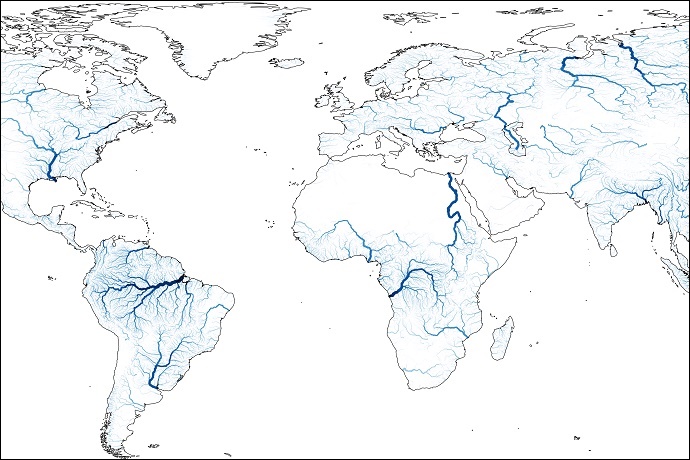
A new, substantially upgraded hydrological reanalysis dataset of the Global Flood Awareness System (GloFAS) from 1980 to July 2022 has been produced by the Joint Research Centre (JRC) of the European Commission in collaboration with ECMWF and released as part of the Copernicus Emergency Management Service (CEMS). It puts river discharge and flood events during that period at the fingertips of users.
The GloFAS v4.0 reanalysis includes daily maps of discharge over the globe at a resolution o
The New RIEGL VZ-600i
By Lurker,
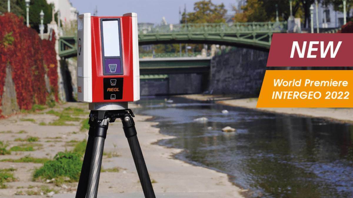
RIEGL’s new era of Terrestrial Laser Scanners: the VZ-600i stands out with extreme versatility, high productivity, radical performance, and game changing mobility features.
With 3D position accuracy of 3 mm and less than 30 sec scan time for high-resolution scans with 6 mm point spacing at 10 m, this enables more than 60 scan positions/hour with real-time registration. Featuring a weight less than 6 kg (13 lbs), 2.2 MHZ PRR, three internal cameras & GNSS integrated, and prepared fo
UP42 Launches ArcGIS Pro Add-in
By Lurker,

The UP42 ArcGIS Pro Add-in is a UI extension that lets ArcGIS Pro users quickly access UP42 storage and projects. The add-in will enable ArcGIS Pro users to seamlessly visualize and analyze their downloaded imagery from UP42 without leaving the Esri ecosystem.
Technical Information
The UP42 add-in for ArcGIS Pro offers users an easy, intuitive way to simplify and streamline their data access and visualization workflows. After ordering geospatial imagery from the leading dat
Pleiades Neo: The Most Detailed and Accurate Commercial Satellite Imagery
By Lurker,

With the 2021 launch and commissioning of the first two Pléiades Neo satellites, Airbus, Intelligence delivered on its promise of providing the highest native spatial resolution Earth observation satellite imagery to the commercial market. And in the coming months, Airbus will double down on its commitment to building the most powerful and versatile remote sensing constellation with the launch of two additional Pléiades Neo satellites.
Much has been said about the Pléiades Neo’s 30cm spati
-
Forum Statistics
8.8k
Total Topics43.5k
Total Posts
-
Latest Posts
-
 Are you ready to level up your geospatial skills? Join our comprehensive training course covering ArcMap, ArcGIS Pro, and ArcOnline—the essential tools for modern spatial analysis and programming! What You’ll Learn: Core functionalities of ArcMap & ArcGIS Pro Cloud-based mapping with ArcGIS Online Automating workflows with Python & ModelBuilder Creating interactive web maps & apps Who Should Enroll? GIS beginners & professionals Urban planners, environmental scientists, & data analysts Developers looking to integrate spatial programming Why Choose This Course? Hands-on projects & real-world applications Expert-led sessions & flexible learning Limited slots available! Click here to register. Let’s shape the future of spatial data together!
 -
GPS is an incredible piece of modern technology. Not only does it allow for locating objects precisely anywhere on the planet, but it also enables the turn-by-turn directions we take for granted these days — all without needing anything more than a radio receiver and some software to decode the signals constantly being sent down from space. [Chris] took that last bit bit as somewhat of a challenge and set off to write a software-defined GPS receiver from the ground up. As GPS started as a military technology, the level of precision needed for things like turn-by-turn navigation wasn’t always available to civilians. The “coarse” positioning is only capable of accuracy within a few hundred meters, so this legacy capability is the first thing that [Chris] tackles here. It is pretty fast, though, with the system able to resolve a location in 24 seconds from cold start and then displaying its information in a browser window. Everything in this build is done in Python as well, meaning that it’s a great starting point for investigating how GPS works and for building other projects from there. The other thing that makes this project accessible is that the only other hardware needed besides a computer that runs Python is an RTL-SDR dongle. These inexpensive TV dongles ushered in a software-defined radio revolution about a decade ago when it was found that they could receive a wide array of radio signals beyond just TV. source: Hackaday and GitHub - chrisdoble/gps-receiver
-
-

-
-
Latest Topics
-
-
Recent Achievements
-


")


