- 1 reply
- 1,330 views
- Add Reply
- 1 reply
- 3,240 views
- Add Reply
- 1 reply
- 2,460 views
- Add Reply
- 0 replies
- 2,187 views
- Add Reply
- 0 replies
- 1,044 views
- Add Reply
Earthquake Hit Syria and Turkey with Magnitude 7.8 R

By Lurker,

On February 6, around 4:15 a.m. local time, a magnitude 7.8 earthquake struck south central Turkey near the Turkey/Syria border. Just 11 minutes later, it was followed by a magnitude 6.7 aftershock. The largest aftershock at the time of writing was a M7.5 aftershock which struck 95 km (~60 miles) to the north. USGS observations and analyses indicate all these events are occurring within the East Anatolian fault system.
Though an earthquake of this magnitude is rare anywhere in the world, th
Innovative system for multidimensional and multitemporal monitoring of the coastal zone using an autonomous unmanned vessel (4DShoreMap)

By 4DShoreMap,
I would like to present a project withthe acronym 4DShoreMap that has been going on for a year.
The project is called „Innovative system for multidimensional and multitemporal monitoring of the coastal zone using an autonomous unmanned vessel” (4DShoreMap). It will use an Auonomous Surface Vehicle called HydroDron-1. The goal of the project is development of a prototype of a multidimensional and multitemporal coastal zone monitoring system using autonomous unmanned floating platforms platfo
Landsat Next: A 26-band 10m resolution Landsat 10

By rahmansunbeam,
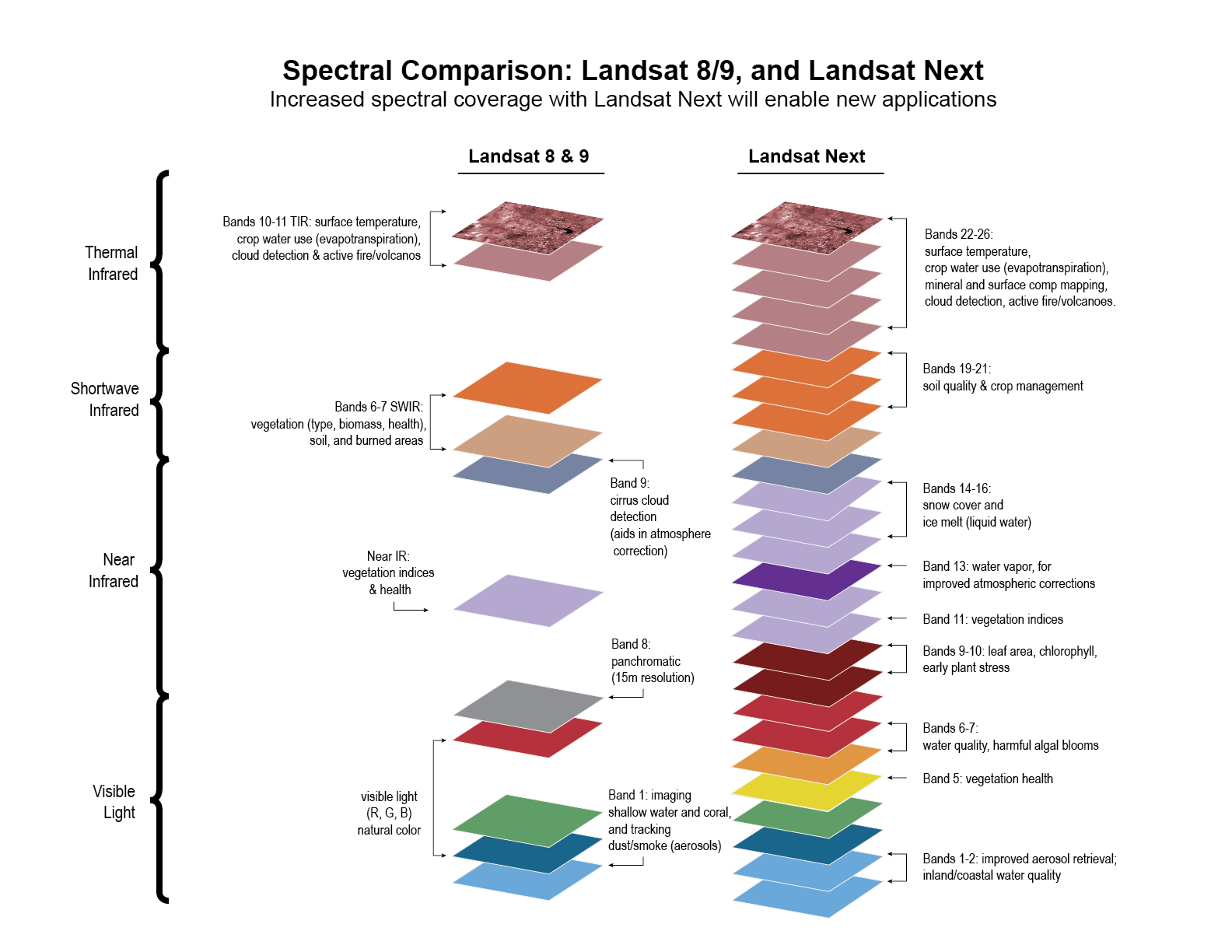
Following the successful launch of Landsat 8 and during the development of Landsat 9, the United States Geological Survey (USGS) and NASA assembled a team of experts from within both agencies for a Joint Agency Sustainable Land Imaging Architecture Study Team to evaluate how to inform an acquisition strategy for a follow-on mission that would best satisfy the diverse and evolving user needs collect by the USGS.
The highest-recommended architecture was a small constellation of “superspectral
China launches Gaofen 11-04
By Lurker,

A Long March-4B (CZ-4B serial number Y55) rocket launched the Gaofen-11 04 observation satellites from Taiyuan Satellite Launch Center (platform LC9), north China's Shanxi Province, Dec. 2022, at 15:37 Beijing time (07:37 UTC). According to official sources, Gaofen-11 04 (高分 十一 号 04, Gāo Fēn Shíyī hào04, “GF11-04”) entered the initial target orbit as planned, and a network with Gaofen-11 01, 02 and 03 will be added to “improve the efficiency of Earth observation and make greater contributions fo
New Satellite Set to Revolutionize Understanding of Water on Earth
By Lurker,
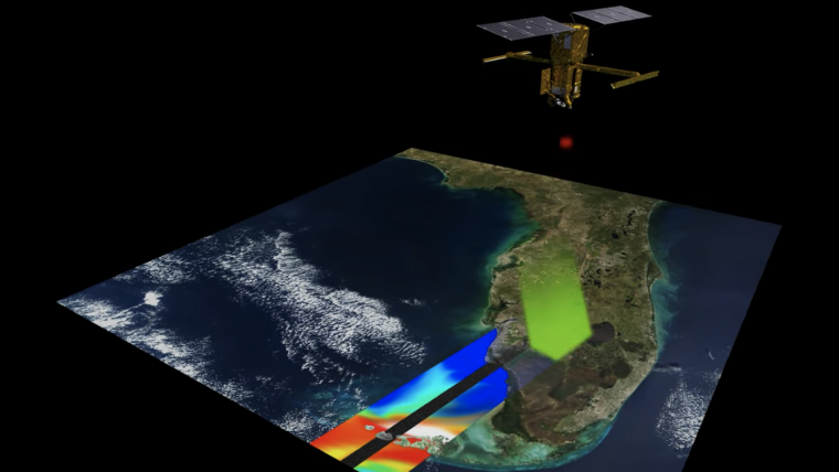
SpaceX, the space exploration company, launched a research satellite into orbit on Friday 16 December 2022. Named SWOT (Surface Water and Ocean Topography), the satellite – which is the size of a large car – will measure the water level on more than 90% of the planet’s surface from its position 890km above the Earth. Scientists will use this data to identify areas vulnerable to flooding or extreme drought, as well as to track the rate of rising sea levels and the resulting coastal erosion.
-
Forum Statistics
8.8k
Total Topics43.5k
Total Posts
-
Latest Posts
-
 Are you ready to level up your geospatial skills? Join our comprehensive training course covering ArcMap, ArcGIS Pro, and ArcOnline—the essential tools for modern spatial analysis and programming! What You’ll Learn: Core functionalities of ArcMap & ArcGIS Pro Cloud-based mapping with ArcGIS Online Automating workflows with Python & ModelBuilder Creating interactive web maps & apps Who Should Enroll? GIS beginners & professionals Urban planners, environmental scientists, & data analysts Developers looking to integrate spatial programming Why Choose This Course? Hands-on projects & real-world applications Expert-led sessions & flexible learning Limited slots available! Click here to register. Let’s shape the future of spatial data together!
 -
GPS is an incredible piece of modern technology. Not only does it allow for locating objects precisely anywhere on the planet, but it also enables the turn-by-turn directions we take for granted these days — all without needing anything more than a radio receiver and some software to decode the signals constantly being sent down from space. [Chris] took that last bit bit as somewhat of a challenge and set off to write a software-defined GPS receiver from the ground up. As GPS started as a military technology, the level of precision needed for things like turn-by-turn navigation wasn’t always available to civilians. The “coarse” positioning is only capable of accuracy within a few hundred meters, so this legacy capability is the first thing that [Chris] tackles here. It is pretty fast, though, with the system able to resolve a location in 24 seconds from cold start and then displaying its information in a browser window. Everything in this build is done in Python as well, meaning that it’s a great starting point for investigating how GPS works and for building other projects from there. The other thing that makes this project accessible is that the only other hardware needed besides a computer that runs Python is an RTL-SDR dongle. These inexpensive TV dongles ushered in a software-defined radio revolution about a decade ago when it was found that they could receive a wide array of radio signals beyond just TV. source: Hackaday and GitHub - chrisdoble/gps-receiver
-
-

-
-
Latest Topics
-
-
Recent Achievements
-


")


