- 0 replies
- 5,392 views
- Add Reply
- 0 replies
- 1,784 views
- Add Reply
- 0 replies
- 1,223 views
- Add Reply
- 2 replies
- 1,561 views
- Add Reply
- 0 replies
- 1,252 views
- Add Reply
STAC Browser v3.0.0 is finally out

By Lurker,
STAC Browser v3.0.0 is finally out! Go and explore awesome geospatial data on the web: https://github.com/radiantearth/stac-browser… Please let us know what you think! More features are already in the pipeline!
This is a Spatio-Temporal Asset Catalog (STAC) browser for static catalogs. Minimal support for APIs is implemented, but it not the focus of the Browser and may lead to issues. It attempts to surface all included data in a user-centric way (an approach which can inform how data is re
June 27 - July 1-Trans-Atlantic Training 2023 (TAT-10): Remote Sensing for Environmental Monitoring and Modelling
By Lurker,
Application deadline is 15 May, 2023!
The main objective of the NASA-ESA Trans-Atlantic Training (TAT) initiative is to train students and early career scientists in the field of Earth Observation through a series of training workshops in Eastern/Central Europe, with an emphasis on remote sensing of land-cover/use change and ecosystem dynamics.
TAT-10 will take place from 27 June to 1 July 2023 in the Czech Republic and will be hosted by Charles University, Prague and Masaryk Universi
GeoServer 2.23.0 Release
By Lurker,
This is a stable release of GeoServer suitable for production systems, made in conjunction with GeoTools 29.0 and GeoWebCache 1.23.0.
With this release GeoServer no longer supports Java 8, and it is time to upgrade to Java 11 at a minimum. Our build system tests GeoServer in with Java 11 and Java 17 which are both long-term-support OpenJDK releases.
The first big internal change for this release of GeoServer is a cleanup of the theme used for the GeoServer web administration app
Introduction of GIS Labs
By Lurker,
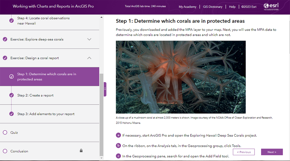
This set of GIS lab exercises is intended to lead students through some of the fundamental skills needed for using ArcGIS Pro and ArcGIS Online as part of an Introduction to GIS course. Created through a collaboration between KSU and UNG.
In keeping with Esri Academy's ongoing commitment to provide flexible options to grow GIS and ArcGIS skills, a brand-new e-Learning format has been added to the Esri Academy catalog. ArcGIS labs are self-paced learning options that emphasize hands-on pract
MapServer Studio available in Beta testing
By Lurker,
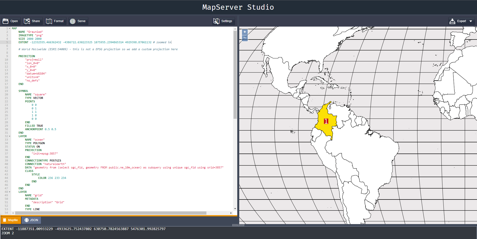
MapServer Studio allows the creation of maps in the browser, powered by MapServer.
Maps are created using MapServer's Mapfile language. Maps are then displayed in a built-in map viewer allowing map images to be created and exported at different scales and locations.
Features
Custom Cartography
Different map projections (not just Web Mercator!)
Custom styling
Custom fonts
Quality Output
High resolution image generatio
-
Forum Statistics
8.8k
Total Topics43.5k
Total Posts
-
Latest Posts
-
 Are you ready to level up your geospatial skills? Join our comprehensive training course covering ArcMap, ArcGIS Pro, and ArcOnline—the essential tools for modern spatial analysis and programming! What You’ll Learn: Core functionalities of ArcMap & ArcGIS Pro Cloud-based mapping with ArcGIS Online Automating workflows with Python & ModelBuilder Creating interactive web maps & apps Who Should Enroll? GIS beginners & professionals Urban planners, environmental scientists, & data analysts Developers looking to integrate spatial programming Why Choose This Course? Hands-on projects & real-world applications Expert-led sessions & flexible learning Limited slots available! Click here to register. Let’s shape the future of spatial data together!
 -
GPS is an incredible piece of modern technology. Not only does it allow for locating objects precisely anywhere on the planet, but it also enables the turn-by-turn directions we take for granted these days — all without needing anything more than a radio receiver and some software to decode the signals constantly being sent down from space. [Chris] took that last bit bit as somewhat of a challenge and set off to write a software-defined GPS receiver from the ground up. As GPS started as a military technology, the level of precision needed for things like turn-by-turn navigation wasn’t always available to civilians. The “coarse” positioning is only capable of accuracy within a few hundred meters, so this legacy capability is the first thing that [Chris] tackles here. It is pretty fast, though, with the system able to resolve a location in 24 seconds from cold start and then displaying its information in a browser window. Everything in this build is done in Python as well, meaning that it’s a great starting point for investigating how GPS works and for building other projects from there. The other thing that makes this project accessible is that the only other hardware needed besides a computer that runs Python is an RTL-SDR dongle. These inexpensive TV dongles ushered in a software-defined radio revolution about a decade ago when it was found that they could receive a wide array of radio signals beyond just TV. source: Hackaday and GitHub - chrisdoble/gps-receiver
-
-

-
-
Latest Topics
-
-
Recent Achievements
-


")


