- 0 replies
- 2,480 views
- Add Reply
- 0 replies
- 1,429 views
- Add Reply
- 2 replies
- 2,149 views
- Add Reply
- 0 replies
- 1,579 views
- Add Reply
- 4 replies
- 4,820 views
- Add Reply
ArcGIS Map for Adobe CC, Perfect for Cartographic Designer

By Lurker,
from their blog :
this extension will provide Adobe Creative Cloud users with web maps so that they can download these maps directly into their Adobe design environment from ArcGIS Online. For example, with ArcGIS Maps for Adobe Creative Cloud, a user can sign into their ArcGIS Online account directly from Illustrator, find geographic content that fits their map requirements, and download this content into their Adobe Illustrator file. It is a seamless workflow since carto
CompassDrone, Shop for Drone Based Remote Sensing

By Lurker,
Interesting shop, hope they add another product,
sites :
http://compassdrone.com/
Global Mapper Mobile Available for iOS Now

By Lurker,
Global Mapper Mobile extends the reach of a traditional GIS by offering access to virtually all raster and vector spatial datasets where they are needed most: in the field or at the job site. Used in conjunction with the desktop version of Global Mapper, the mobile edition can display both raster and vector layers from any of the 250 supported formats. Data is quickly and easily transferred to the device in the form of Global Mapper Mobile Package Files that efficiently compress multiple layers
ArcGIS Python API (Beta) Announced

By Lurker,


The API lets users perform GIS visualization and analysis, spatial data/content management as well as organization administration, using both an interactive console, as well as scripts in a batch processing environment.
The API integrates well with the Jupyter Notebook and the SciPy stack, enabling academics, data scientists and GIS analysts to share programs and reproducible research with others.
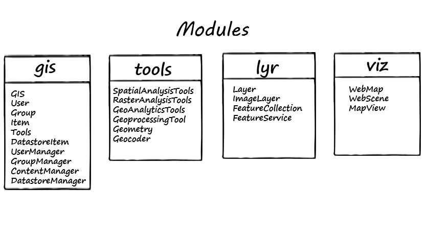
The API has a modular design that makes it simple to use and understand. These modules c
TopoMapCreator (beta)

By darksabersan,

TopoMapCreator (beta) A set of GIS tools that helps creating topographic map
TopoMapCreatorThe TopoMapCreator consists of of 5 Programs: MapCreator, GeoToolsCmd, TopoMap, EcwToMobile and ExtendedMapCreator. More information for example about how to install it, you find under TopoMapCreator.
Now read, what the 5 Programs are doing:
1. ExtendedMapCreatorExtendedMapCreator is a Desktop-Program, that creates "Topographic Maps" from OSM, NASA and ESA. You simply define a map extent by draggi
-
Forum Statistics
8.7k
Total Topics43.4k
Total Posts


